|
Welcome to Skyepony's Weather Blog.
|


Lightning in Florida Returns With a Vengeance
Thursday, June 29th a nine month pregnant woman was struck in Fort Meyers, in a gated community. She was hospitalized for her injuries. A BJ's Wholesale store less than two miles away was also struck, causing smoke and haze. The manager evacuated the store for a while after. Monday a Nocatee home in St Johns County was struck by lightning and burnt down. A dog was saved from a small closet and has since recovered. The Tucker Fire in West Cocoa was started by lightning, also on Monday. It grew to over 4,500 acres before being put out by a heavy rain later in the week. So far this year three people have been killed by lightning. Two of the deaths occurred in Florida. Since January 1, 2007, 304 people have died from lightning strikes in the United States and 8.8 billion dollars worth of insurance claims were filed because of it. Florida remains the deadliest state for lightning with 52 killed by it in the last 10 1/2 years.. Texas came in second with 21. If you can hear thunder the storm is close enough to strike. Take cover!
Below is a cat that thought it would be fun to do a little storm watching in Jacksonville, FL this week, until lightning convinced it otherwise.. NANMADOL 05W
94L
 94E 
Comments
The burnout along I-95 is now complete. Here is some pictures from the morning commute before it was. Tucker Fire was started by lightning in a fairly inaccessible area west of I-95 on Monday June 26, 2017 near Cocoa, FL. I-95 has been closed on and off over this wildfire. The wind has currently shifted away and it is open for now. Drivers are being cautioned for smoke hazards in the area. I-95 may close again depending on conditions. Current road statue can be found at the Florida Highway Patrol Incident Map.
04E DORA

97W

White Mountain Apache Tribe Needs Water
Cibecue, Arizona is suffering in the heat wave with failed pumps and very little water. The White Mountain Apache Tribe is declaring an emergency. They are requesting cases of bottled water be dropped off at the Navajo County Board of Supervisors Offices in Holbrook, or to the Reception Desk in Show Low at 550 N. 9th Place. This area is only receiving about 5% of their normal water amount. Yavapai County is in less dire need. The heat has upped usage to the point of straining the limits of their equipment though it's still functioning. They are requesting people to conserve at least 50% of their normal use.
Hot Vegas
Tropics
04E Dora
 97W 
Cindy 03L
     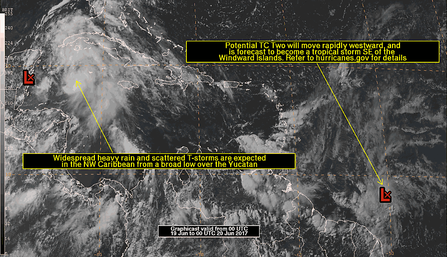 93L  Potential 02L 
Parts of Jamaica are flooding from 93L. This is a sad video from yesterday. Strong warning and spoiler alert the dog gets electrocuted to death but saved some kids from the same fate. It's best to stay out of flood water.
93L should pull together within 24hrs. Models diverge after that with ECWMF and NASA's model going for most northern Mexico and most others heading for LA, MS/North Gulf area. It's broad and full of rain so not a storm to just watch the track, flooding is the bigger concern. Might make it to hurricane strength but will most likely landfall as a tropical storm.
92L is affecting the islands this morning. Land and shear should open it into a wave not far in to the Caribbean Sea. GEOS-5 has been showing it reprise as a depression with the remnant of 93L back into Northern Mexico around June 27th (8 days from now). Flooding in Chile
Four have died with 3000 put out of their homes by flooding in Chile. The worst is occurring in the Southern part of Bio Bio where a river came out of it's bank.
Is La Nina Coming?
ESPI is falling hard. Today it is -1.81. This is screaming La Nina is nigh! Well months away, but coming if the atmospheric conditions keep tending this way.
NASA's GEOS-5 model has been forecasting the NW Caribbean storm since 240hrs out. At first had it going toward Florida with subsequent runs bringing a quick shift toward the west. The last several days has had it running over the tip of the Yucatan, it's ended it in Mexico mostly, Texas occasionally. Seeing the ECMWF jumping on board with it this morning. Here's GEOS-5 00Z run.
  Other notable models is CMC which has consistently doomed Florida or the Northern Gulf coast & navgem which has the storm forming south of Jamaica, hitting the west end of Cuba as it threads the needle on the way to Southern Mississippi and Alabama.   
92L
Neither the ECMWF or GEOS-5 is liking the possible storm forming in the Mid-Atlantic this morning. Though it was showing enough promise to be declared 92L in the night. It is located 5N 33.3W, is estimated to have 20kt winds and a pressure of 1009mb.

SAB Tropical Review Update
Good news for now...
Concerned Users, NESDIS and NWS leadership are currently engaged in ongoing discussions regarding SAB's Tropical Program. I believe no changes are likely through the end of the calendar year. Mike Turk SAB Tropical Team Lead Remnants of Calvin 03E East Pacific Merbok 04W West Pacific
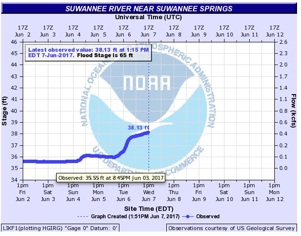
Just happened to capture some photos of Suwannee River near Suwannee Springs at an all time low river record. These pictures are from Sunday June 6, 2017 when the river gauge read 35.61ft. The previous day the river was at an even lower, at 35.55ft. Both heights beat out the old record set October 6, 2011 of 35.88ft.
The river has risen since with tropical moisture coming out of the Gulf of Mexico. Hovering a cursor over Saturday evening's gauge data shows the unofficial record.
Tropics
95A

|
Current Tropics and Weather News..
Archives
January 2022
|

 RSS Feed
