|
Welcome to Skyepony's Weather Blog.
|


Overall Staple Crops Did Well, Tariffs make them Hard to Sell Early winter storms have begun hitting corn and soybean crops not yet completely harvested in the the northern states. Many were planted late due to spring flooding and are behind the average harvest date. We would expect around 50-60% of those crops already to be up for the winter in the Midwest, where this year only 25-30% have been harvested so far. The moisture and storms are overall impeding the pace of the harvest. Luckily an overabundance was planted. The trade war with China is also a factor, though it appears they went ahead and purchased a good bit of soybeans from Brazil, perhaps reducing risk on how bad the United States harvest goes. The demand for eating corn is down. Exporting larger amounts of corn as ethanol may happen depending on trade agreements. Wheat crops have been slowed slightly in Canada by the weather as well but not like Argentina or Australia where devastating droughts have taken hold and reduced the export outlooks excessively. Vietnam has suspended imports from Russia for phytosanitary (not meeting disease free standards) issues, that leaves America, Canada and Ukraine to fill the wheat crop void. Cranberries look to be abundant this winter. The last several years US growers have been introducing Chinese taste buds to them. Ocean spray and Minute Maid have been expanding their market into this new consumer of cranberries, only now to have 40% tariffs put on their product causing demand to plummet. Holiday fruit cakes maybe the rage this year. There is also a gluttony of pecans. Though 2018 Hurricane Michael effects that ravaged Georgia trees are still being felt, the rest of the country's pecan growers have produced well and Mexico has more than made up for the loss. China put high tariffs on the nut, reducing their imports by about 75% and India has refused to lower their high tariffs. Overall United States pecan prices have fallen and the Georgia crop is looking better than expected with the long dry spell that has been reducing the hay crop yet helping the pecan harvest. Oysters Largely Died in the Mississippi River Flood Water Louisiana Oysters have taken a real hit from the historic Mississippi River flooding earlier this year. The fresh water inundation from the flooding and two openings of the Bonnet Carre Spillway have brought ill suited living conditions to the oyster beds. Losses have ranged from 30-100%. Some third generation oyster farmers are closing down. In the hundred years oysters have been an industry there, farmers claim it has never been this bad, including Hurricane Katrina and the BP oil spill. Oysters are being set aside for the better dishes. Prices are quickly rising. A Po Boy sandwich is becoming a rarity and running near $20 in New Orleans.
Comments
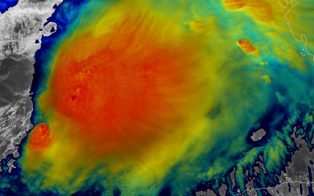
A GOES-16 Night-IR shot of Nestor at 17:49Z, not long after he is declared.
Tropical Storm Nestor has been named by NHC, this is the 14th named storm of the season. It has winds of 60mph and a pressure of 1001mb. The current movement is Northeast at 22mph. NHC main points are.. ...DANGEROUS STORM SURGE AND TROPICAL STORM FORCE WINDS EXPECTED ALONG PORTIONS OF THE NORTHERN GULF COAST LATER TODAY AND TONIGHT...
Below is self updating graphics from National Hurricane Center. Refresh for latest.
  Long Range Radar From Tampa
Live storm chasing with Mark Sudduth.
The Northeast had a record October bomb cyclone dropping the pressure in Boston to 975.3mb. The pressure fell 30mb in 15hrs from Wednesday evening into Thursday morning. More than a half of a million people lost power as trees took out power lines. Schools were closed, trains stopped, boats broke free and sank offshore.
In the Gulf of Mexico a storm is expected to pull together. It is being called Potential Tropical Cyclone Sixteen (PTC16) and is expected to develop Friday and make landfall Friday night into Saturday. PTC 16 may have much of the storm sheared to the east and north of the center. Concerns are heavy rain, severe weather and storm surge for Georgia, Florida, coastal Carolinas and Alabama. After the weekend subtropical or tropical storm, look for severe weather to develop on the tail of a low that forms over the Dakotas and moves east. The worst of which maybe in the south, between Oklahoma and Alabama. 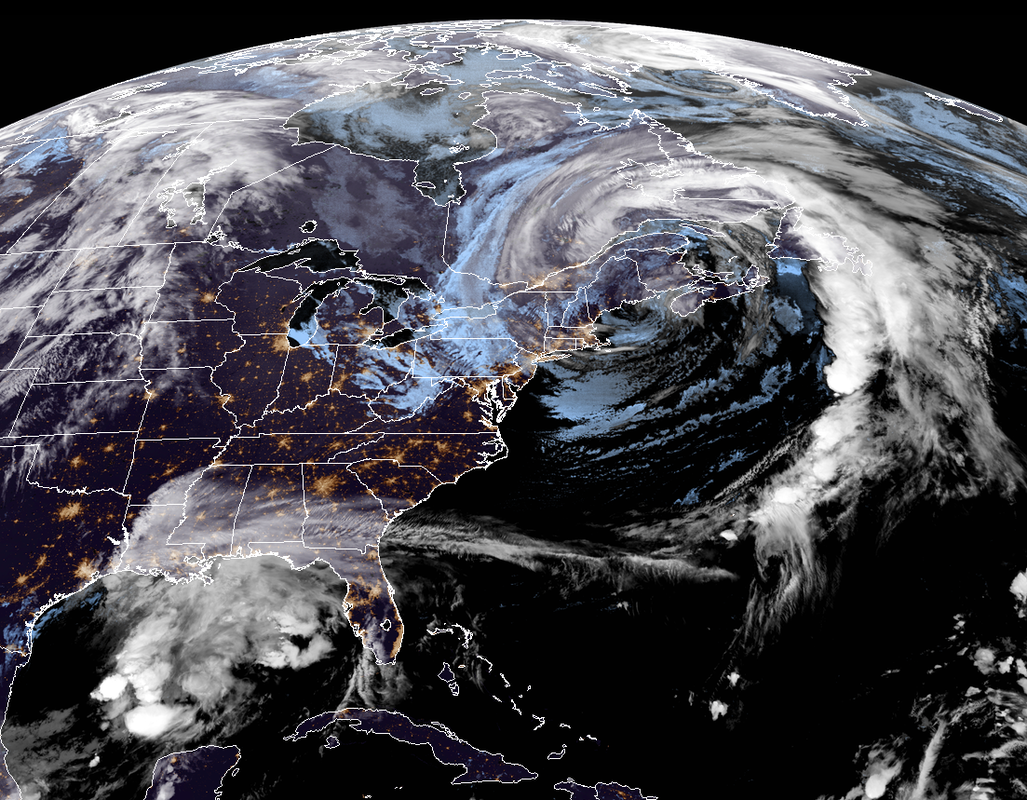
Leaving a few self updating graphics. Refresh page or visit again for latest.
 Seven day Precipitation Forecast Total  Cedar Key Storm Surge Forecast  NOAA Extra-Tropical Storm Surge 2.2 Southeast 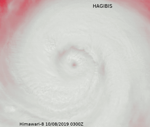
Hagibis has rapidly intensified into a Super Typhoon and hit an uninhabited island squarely. It maybe on it's way to Japan.
Leaving some embedded live graphics and videos below. Refresh for the latest.
Looking ahead here using NASA's GMAO S2S seasonal model. Fall is on and for North America enjoy the cold now because the forecast has been getting hotter for winter with perhaps a weak reprieve for the west half in January. The effects of El Nino are fading fast as the consequences of climate change are showing more. 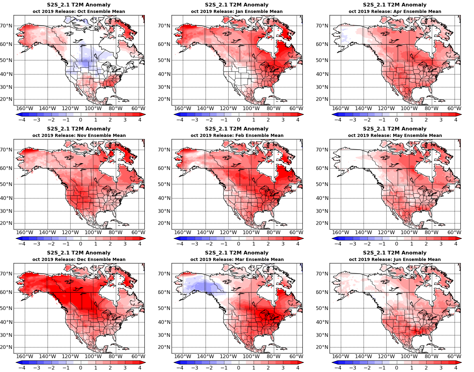 Figure 1. The Temperature Anomaly 2 meters above the earth for North America. Globally the patches of cooler air at the poles may warm after October. November and December look particularly warm for the Arctic with only Greenland remaining near average. India stays cooler til the end of winter as does parts of Asia 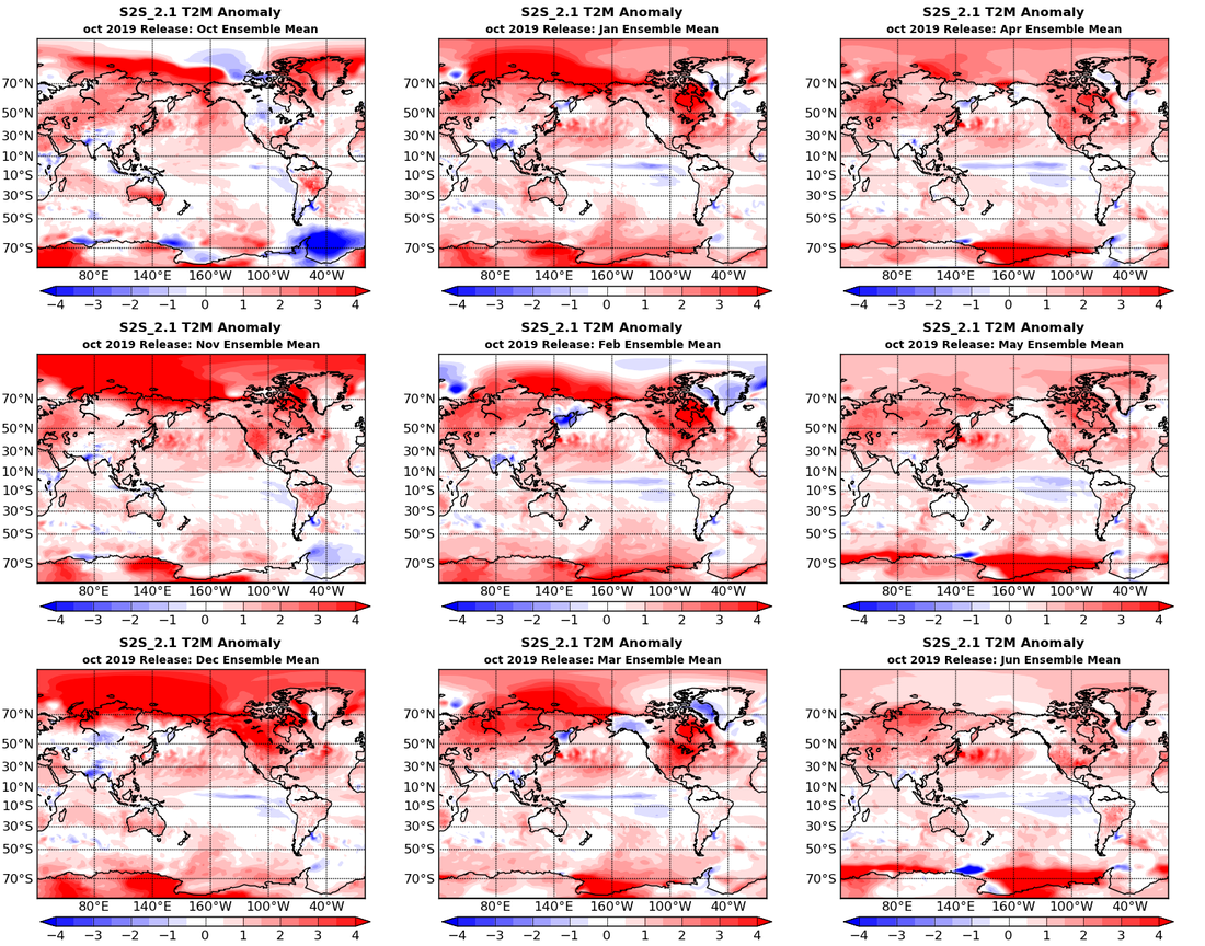 Figure 2. The global Temperature Anomaly by month, 2 meters above ground. This looks like a dry fall and winter for the southeast, most of which is already Abnormally Dry with some spots coming in D3 or Extreme Drought. There is hope for a pattern change and reprieve in January but quickly reverses to tease a bad spring fire season. A memorable fire season somewhere in the south is typical the spring after El Nino dissipates. The West Coast may see a dry winter with some rain on either side. Late winter and spring may bring a lot of precipitation back to the Midwest. 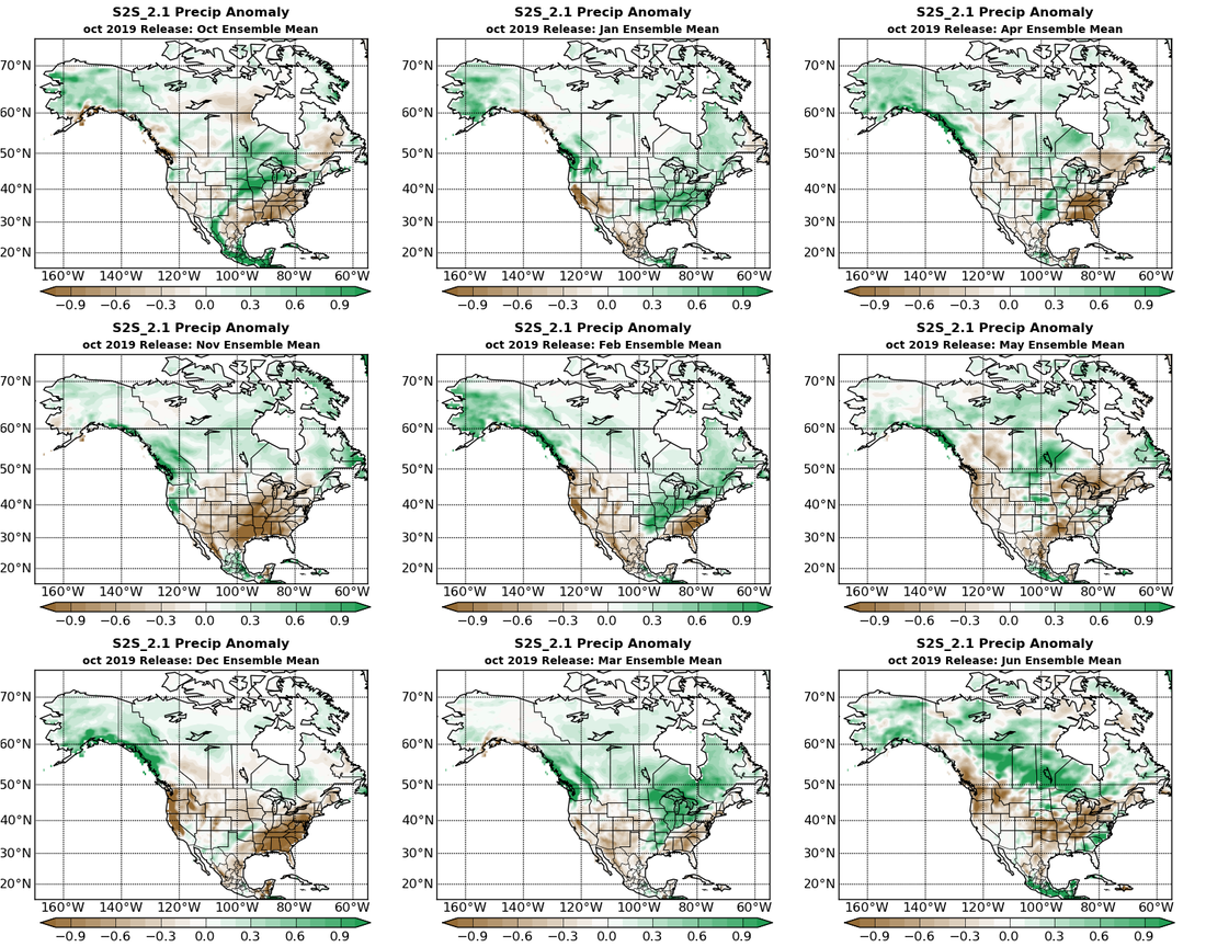 Figure 3. Precipitation Anomaly by month for North America. Global Precipitation Anomaly doesn't appear too extreme anywhere except for Southeastern Asia, looks really dry. India's floods may continue to some extent through December. Europe overall looks like it is in for a wet winter, except the extreme west shore. Individual regions can be selected here. Current ENSO conditions are neutral with a ~75% chance to stay neutral for Fall and ~50-65% chance of remaining neutral through Winter according to NOAA. NASA's GMAO S2S model is indicating a continued progression toward LA Nina with the below normal equatorial Sea Surface Temperatures dropping to La Nina conditions and continuing through the spring. Currently the T-Depth Anomaly is a clash of colors/temperatures with larger variations from week to week. Region 3.4 has shot up to 0.5 this week. This is partly due to the beautiful Instability waves of cold water being drawn up from the west coast of South America. 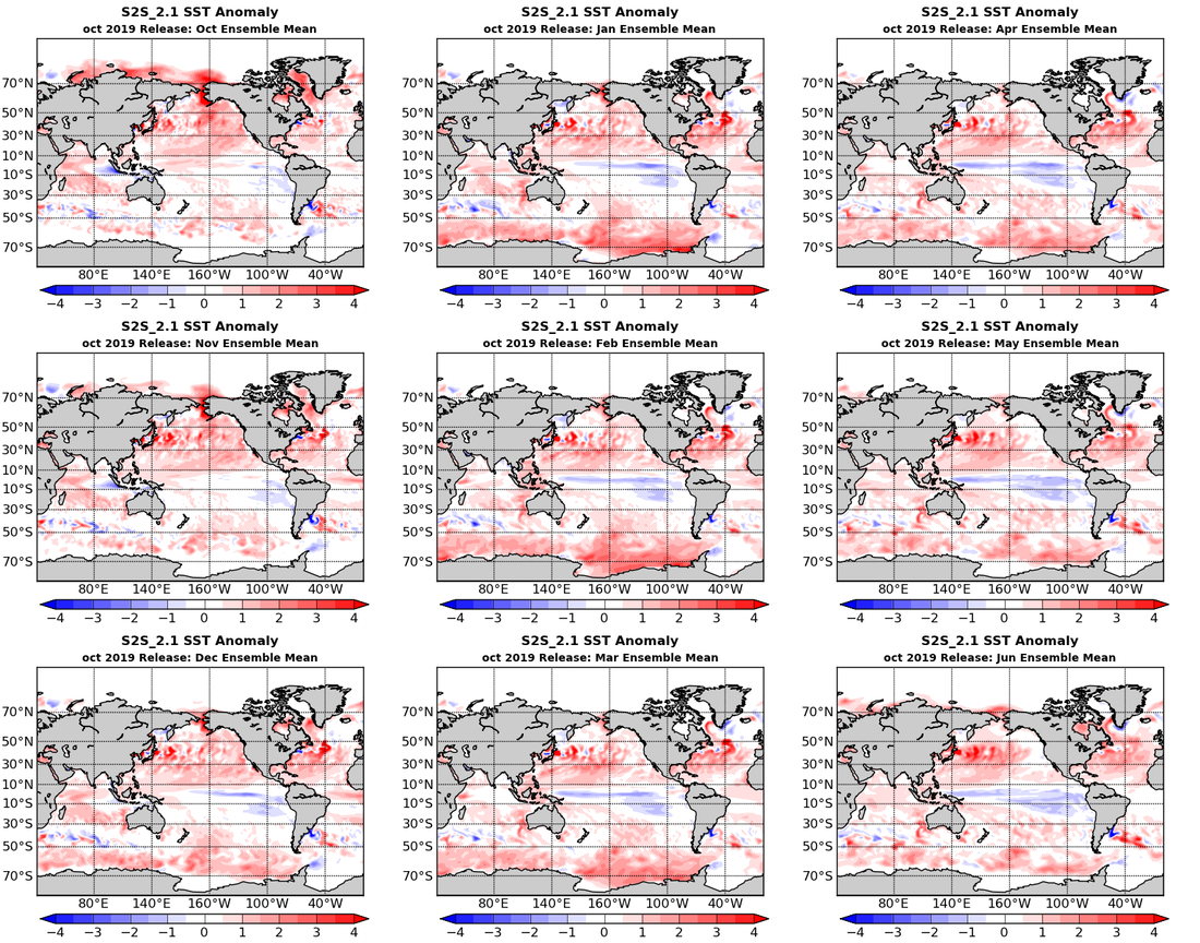 Figure 4. Global Sea Surface Temperature Anomaly
With the North Atlantic Sea Surface Temperatures expected to stay warmer than normal going into winter and the Tropical Cyclone Heat Potential remaining, hurricane season doesn't look over. MJO is coming back around. May even see some tropical activity this coming week in the Atlantic. Models are scattered about weaker and subtropical storms with a possible strong seasonal sort of storm coming out of the Caribbean in a few weeks. A fire consumed more than 4.100 acres between Central and west Maui, in Maalaea. The wildfire got in to a wind power farm that had to be evacuated along with some houses. Over 200 day trippers from a cruise ship were stranded on the other side of the fire. The fire burned down to the road as residents and tourists were fleeing as seen in the video below. It has been contained, still burning but major roads are reopening. |
Current Tropics and Weather News..
Archives
January 2022
|


 RSS Feed
