|
Welcome to Skyepony's Weather Blog.
|


|
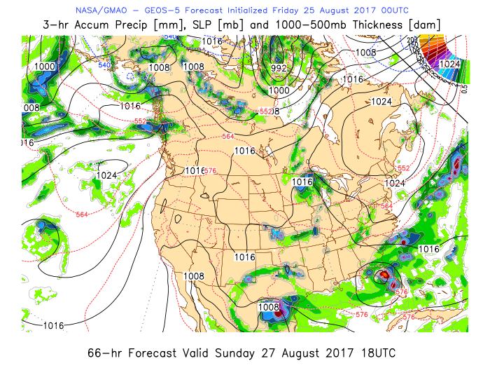
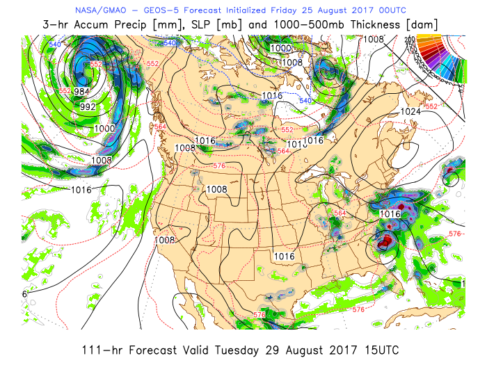
Harvey has continued Rapid Intensification overnight. At 9am he was 948mb with 110mph winds. He is moving overall Northwest at 10mph. This forward speed is expected and beginning to slow. Harvey may be over the same general area for days. There are areas in Texas where this is a life threatening situation coming on. Heed local warnings. Some places deadly 9-12' surge is expected, devastating winds can't really be ruled out yet either.
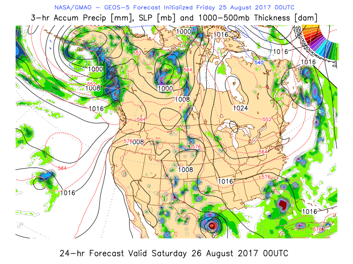
Overall coastal areas along the Gulf Coast and East Coast should be gathering and at least planning for the unexpected. This could go a few different ways. There is uncertainty with different tropical entities close together like this. Either Harvey stays in the landfall area, maybe even comes back off shore and landfalls again more to the north but generally drowns a lot of Texas with rain and surge. While the wave near Florida develops on the east coast, maybe grazing North Carolina on the way out to sea. Or, Like GEOS-5 has insisted Harvey continues a more west track. Texas would be a hard hit but it wouldn't linger as long. Mexico gets lots of rain as the whole thing traverses land to get sucked into a Low in the East Pacific. If this happened the Low around Florida might develop (starting tomorrow) more on the west coast & over the state, then possibly run up the east coast. Either scenario several large areas could receive scary amounts of rain.
Rockport, TX just inland behind the barrier island. Source is Russpoint's Wundercam.
Corpus Christi, Texas on the barrier island. Source Joe Diver's Wundercam. This one is more inland, between Bay City and Victoria, where one of the highest storm surges is forecast. Source is K5HAS's Wundercam. 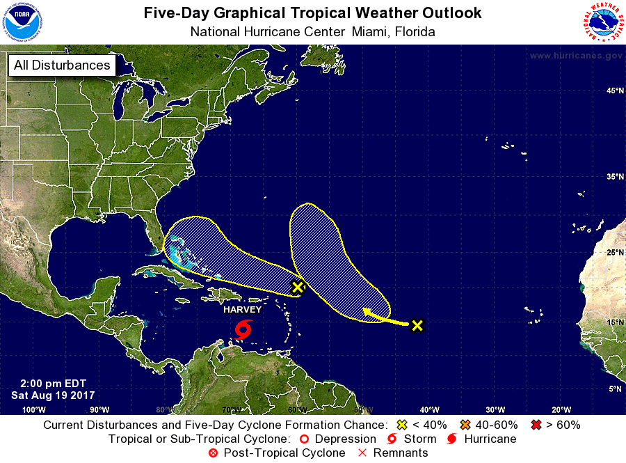 A little south of here in Indian River County is Fellsmere, FL. It's mostly known for it's agriculture and rodeos. Yesterday a tornado touched down in a field..Here is the view from County Rd 512. Here is a quick close up.. Also on Friday, just north of here, was a funnel cloud spotted in Rocklegde, FL from a tornado warned cell. 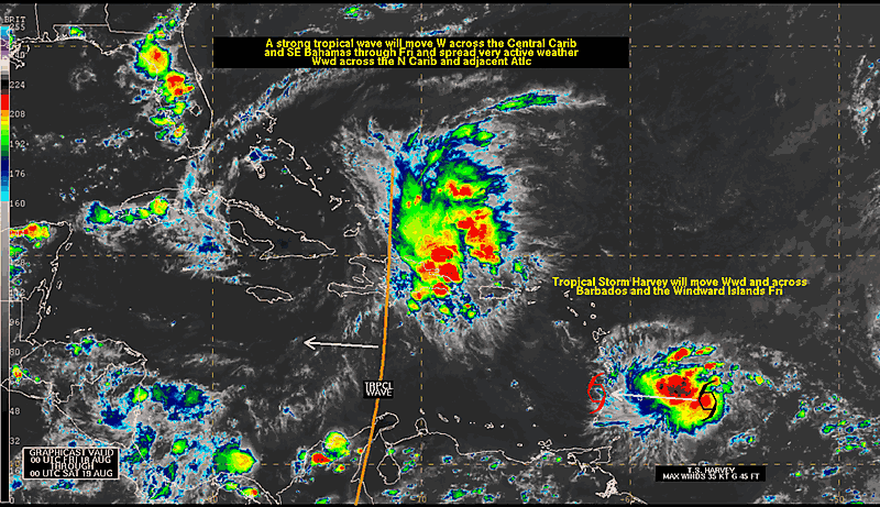 Published on Aug 17, 2017 by: NPI Productions
Hurricane Gert sent a fun 3-4 foot swell and every surfer in Florida was on it. Almost thought we were at lowers for a moment! SpaceX launched a Dragon Capsule to the International Space Station today at 12:31pm. The weather was hot but clear enough. Watched the launch at 39A from the Turn Basin. The renovations out there continue. Still bits of minor damage from Matthew around. The burned areas from the fires last spring were widespread. Saw where a Bald Eagle's nest should have been was torched tree. Launch was amazing. Sound was incredible. To watch Dragon come back to earth..that was something to behold.
99L after a long battle with dust and shear has become 08L. It has a chance at modest intensification over warmer waters before shear sets in again in 2-3 days. NASA's model doesn't get really excited about this storm. It may get named. Probably not get really strong. What a full moon...produced a baby storm. Check back for more pictures later today including some puppies born on another farm. Welcome Nickel-Moo.. The rain from Noru extends well to the north into Southeastern Russia. Heavy rain has caused unexpected flooding Published on Aug 6, 2017 by: NOLA.com
A dramatic rescue during the Louisiana Flood of 2016 was the subject of a Coast Guard ceremony where the agency presented a Silver Lifesaving Medal and three Meritorious Public Service Medals on Aug. 4, 2017. The Silver Lifesaving Medal honored David Phung for his heroics in saving a woman and her dog from a submerged automobile near Baton Rouge on the afternoon of Aug. 13, 2016. (U.S. Coast Guard video) New Atlantic Invests
99L
99L is fresh off Africa and west bound.

90L
90L is in the Eastern Caribbean

07W NORU
Cocoa Beach Pier is Closed, Three Hurt
|
Current Tropics and Weather News..
Archives
January 2022
|
 RSS Feed
