|
Welcome to Skyepony's Weather Blog.
|


|
Globally we've reached that phase where all the Tropical Depressions and invests either matured to Tropical Cyclones or died. We are left with four storms: Nana & Omar in the Atlantic, Maysak & Haishen in the Western Pacific. Three are threatening land. Embedded graphics for those storms below that should update when refreshed.
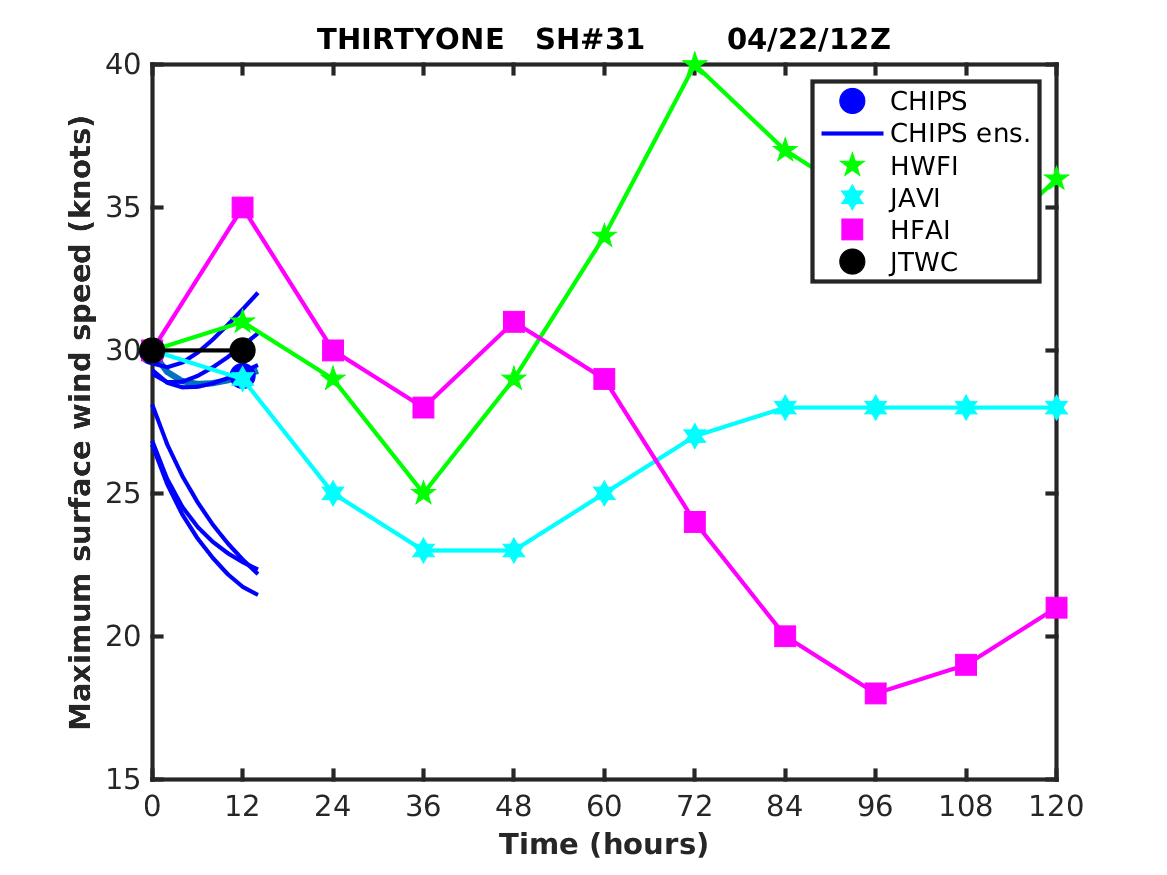
16L NANA
   10W MAYSAK and 11W HAISHEN      Growing Slide Show of Omar and Nana
Omar was confirmed to still have 35kts by ASCAT and Dvorak CI this evening. The storm is battling heavy shear from the Northeast. It may become a remnant low sometime later on Wednesday. Models have been not at all consistent on this storm. If Omar persists we will most likely see the high come back west, blocking storms from re-curving over the next few weeks.
Check back for more saved images and updates on these storms.
Severe Weather
The day started with flooding reports and rescues in Arkansas and North Carolina. Before the day was over nine tornadoes were reported between Arkansas and Texas. There was an entrapment, barn lost a roof, chicken house and warehouses destroyed. Wind reports came from New Mexico to Tennessee, tore off mobile home roofs, flipped a stock trailer, downed trees and causes power outages. There was also three reports of inch size hail.
Beach Tornado in Italy
Comments
Severe Weather Watching Plains and South / Cyclone Jelawat Declared / Cyclone NORA Aftermath3/27/2018
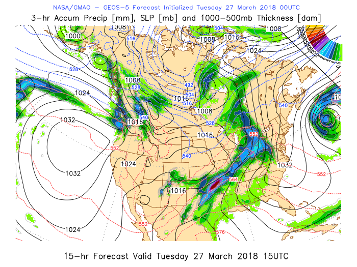
As a cold front pushes into the plains and south the atmosphere is destabilizing a bit this week. So far today there has been only one wind report to the Storm Prediction Center with trees damaged and limbs snapped in Sebastian, AK. Later today there is a slight risk across parts of Texas with marginal risk extending over a large area from The Four Corners thru Texas & back up into Ohio. Mississippi River Basin is taking more rain. They should have near completely closed the Bonnet Carre Spillway from the last flood. With this rain forecast it was announced the other day that a second opening may happen. It would be the first time ever it was opened twice in one year.
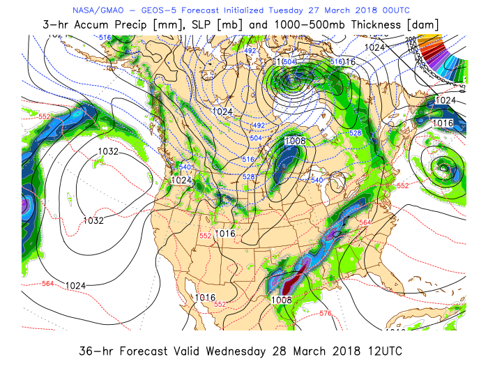
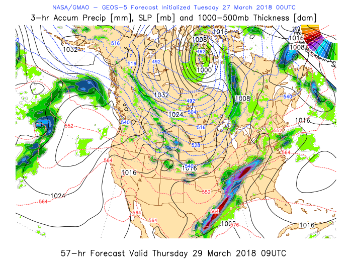
GEOS-5 has today's worst weather in Oklahoma. Wednesday still looks like the most severe day and concentrates it in Texas. Thursday has the worst now over coastal Texas, with lesser thru Louisiana, Mississippi & more severe in Tennessee.
Tropics
03W JELAWAT..................................................................17P IRIS
Cyclone NORA Aftermath
Cyclone NORA has degraded into a remnant low but much of it's water remains over Queensland & Northern Australia. 40 people were rescued from two Cairns caravan parks in the flood. The youtube below captures some of what is described here, where the campers were smashed into buildings from that event when 100mm of rain fell in a minute.
floods in Cairns, Tropical cyclone Nora damage, inundations Queensland , North Australia Cities of the World
Published on Mar 27, 2018floods in Cairns, Tropical cyclone Nora damage, inundations Queensland , North AustraliaQueensland damage, queensland storm, Australian cyclone, Australia Cyclone Nora Mike Hughes Launches His Homemade Rocket Mike Hughes launched in his homemade rocket Saturday in California. It went 1,875 ft in altitude before deploying two parachutes and taking a hard landing. Mike still looks undecided on if the earth is shaped like a Frisbee. He has plans to build a rocket that launches from a balloon and could go 68 miles in altitude. He also has plans to run for governor. Lookout For Next Week's Weather The two most prominent features of the coming week's weather are some fun swirl watching in the Atlantic and severe storms, the worst probably being in Texas and Oklahoma. The swirl watching should come from the storm over the Mid-Atlantic states. It should push off over the Carolinas. When it first spins up and has the most convection it should be half frozen. Once it detaches from everything and warms up as a storm, it weakens. NASA's model never shows this firing from the center so it shouldn't make any sort of Sub-tropical classification. Wednesday and Thursday may be severe weather days for Texas with some spilling into Oklahoma. Thursday night into Friday the system moves east some as other part of the south begin to take bad weather..notably bad is Mississippi.  Weather News
Part of Hurricane Harvey disaster relief has been unemployment for those whose job was lost due to the storm. This will be ending February 24th. Those affected are encouraged to seek work or enroll in job training, more info and opportunities here.
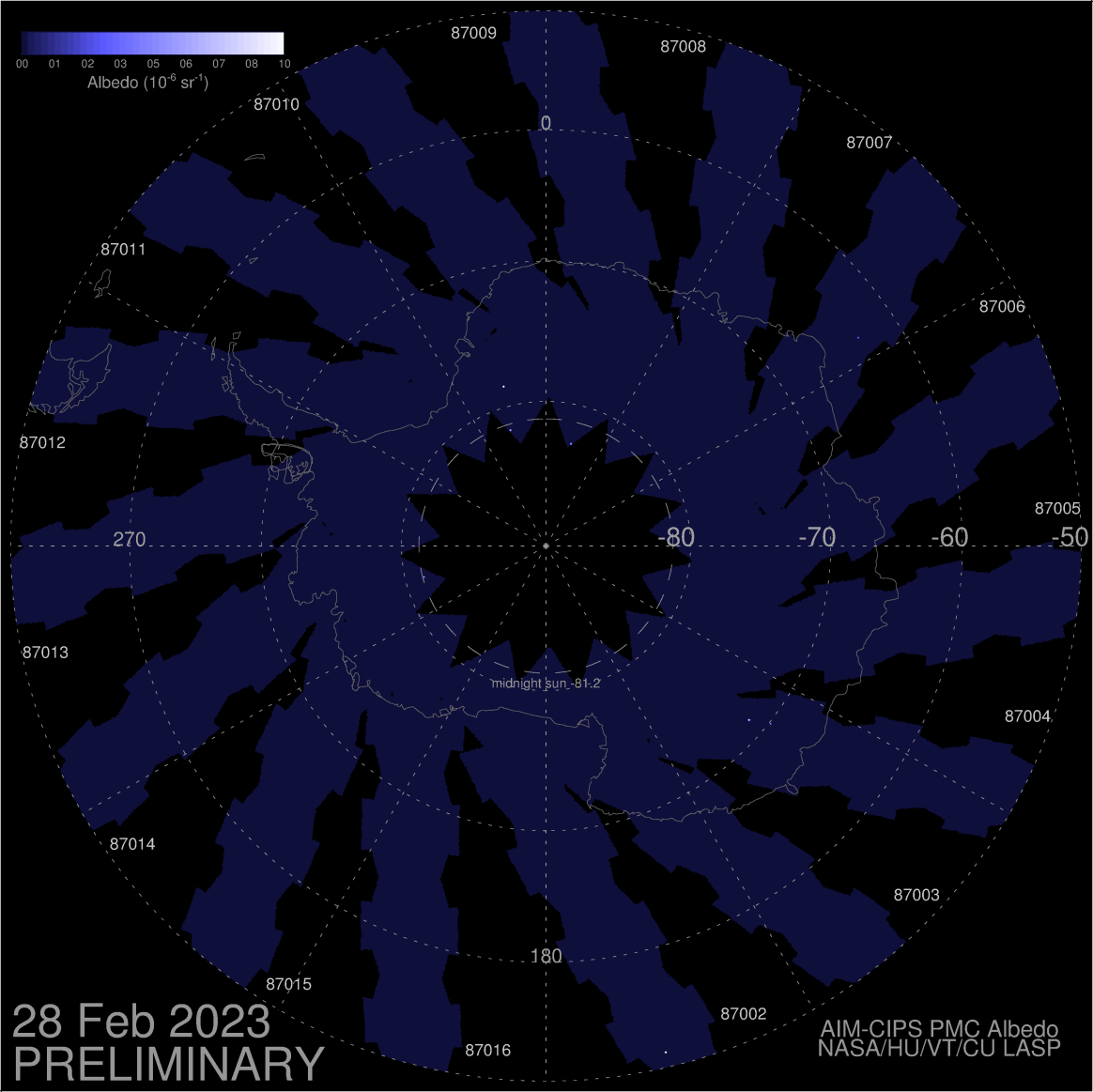
ESPI remains steady at -1.10 The connection with NASA's AIM satellite has been restored. Noctilucent clouds can be seen again at SpaceWeather.com.
 Next Storm
The evolution of the storm pulling moisture from the Gulf of Mexico this coming weekend still looks likely. The Northeast maybe not as impacted as this trends east. Severe weather outlooks have varied in intensity. Coastal areas looking most impacted now.
Things Are a Little Shaky
Earthquakes and Volcanoes have been active lately. Including current, self updating maps for both.

[enlarge]
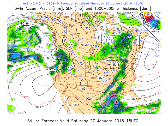
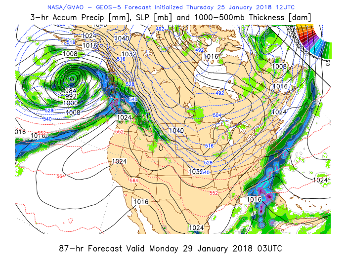
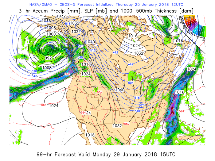
Looking at tomorrow storms are only expected in the far corners of the nation with some lake effect snow. The storm coming to California doesn't look like it will effect the mudslide area in Southern California. Good progress has been made, Highway 101 has been open since Sunday. All the dranage ways are yet to be cleared though. The next 10days should be dry for this area with the precipitation impacts reaching from Canada through Central California.  The storm just beginning to impact the west coast now will be one to watch as it traverses the country and pulls moisture from the Gulf of Mexico. Though not looking as ominous as modeled a few days ago it could bring more severe weather than the storm that came through last (video below). The cold shouldn't come as far south but maybe more moisture out of the gulf for the southeastern states over the coming weekend. Monday, January 29th maybe a rough travel day across the Northeast with heavy snow on the west side of the storm and less frozen precipitation along much of the coastal areas. 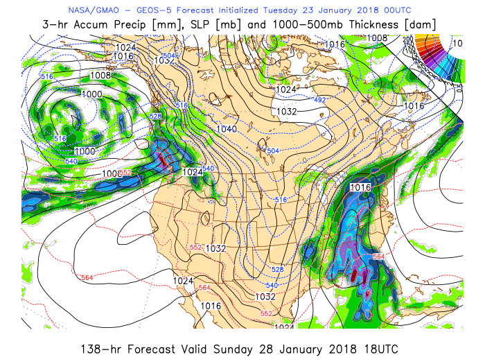 |
Current Tropics and Weather News..
Archives
January 2022
|


 RSS Feed
