|
Welcome to Skyepony's Weather Blog.
|


|
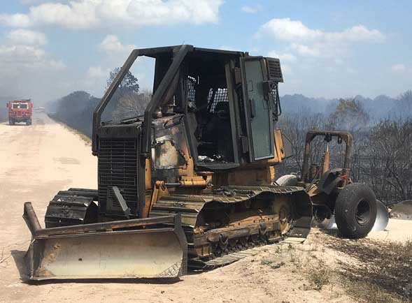
Florida Fire Danger Map..................Bulldozer lost to a wildfire about 13 miles southwest of Yeehaw Junction, 4/16/2017. The operator escaped unharmed. The fire eventually grew to 450 acres.
  What is burning in Florida Large Wildfires Across the United States US Fire Activity Public Information Map TROPICS
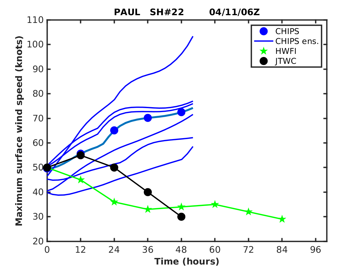
18P Donna     ~~~~~~~~~~~~~~~~~~~~~~~~~~~~~~~~~~~~~~~~~~~~~~~~~~~~~~~~~~~~~~~~~ 01E..............................................................................19P ELLA   Hiatus Pictures

Comments
FLORIDA WILDFIRES
Though Central Florida had a greater increase overall in the number of wildfires burning over the last week, as well as near daily major road closures, South Florida still has the largest active Wildfire.
The Cowbell Fire is now 17,594 acres and 50% contained. 294 personnel are working the wildfire with seven helicopters, two single engine air tankers and 22 engines. Yesterday, in favorable fire conditions a spot fire took hold west of Nobles Grade, increasing the overall fire size by 636 acres. Today firing will continue on the West and North sides trying to keep the fire out of Kissimmee Billy Strand and Big Cypress Preserve. South and east sides mop up continues. The structural preservation crew is removing equipment to protect the Sanctuary Community. Several closures are still in effect.

TROPICSWILDFIRES
Gov. Scott declared a State of Emergency for the Florida Wildfire situation today. Over 23,000 acres are actively burning and 19 structures have recently been lost.
Some of the larger fires are burning in Big Cypress Swamp located in South Florida. The Parliament Fire is now 95% contained but is 26,471acres in size. Cowbell Fire is also in Big Cypress, this is a growing threat, now 10,435 acres and 5% contained. There are homes 1.25 miles to the east of this fire that maybe impacted in 72hrs. Home preparations are taking place. Over 250 firefighters are working this fire with the help of various equipment, including helicopters (pictured right below). There are many camp, land and trail closures in Big Cypress. Just south of Big Cypress the New River Fire has just got started. It is 70 acres and located east of Everglades City half in Big Cypress and half in the Everglades.  
TROPICS
Atlantic Swirl Watch

Pacific and Indian Ocean
Fire Weather Weekend
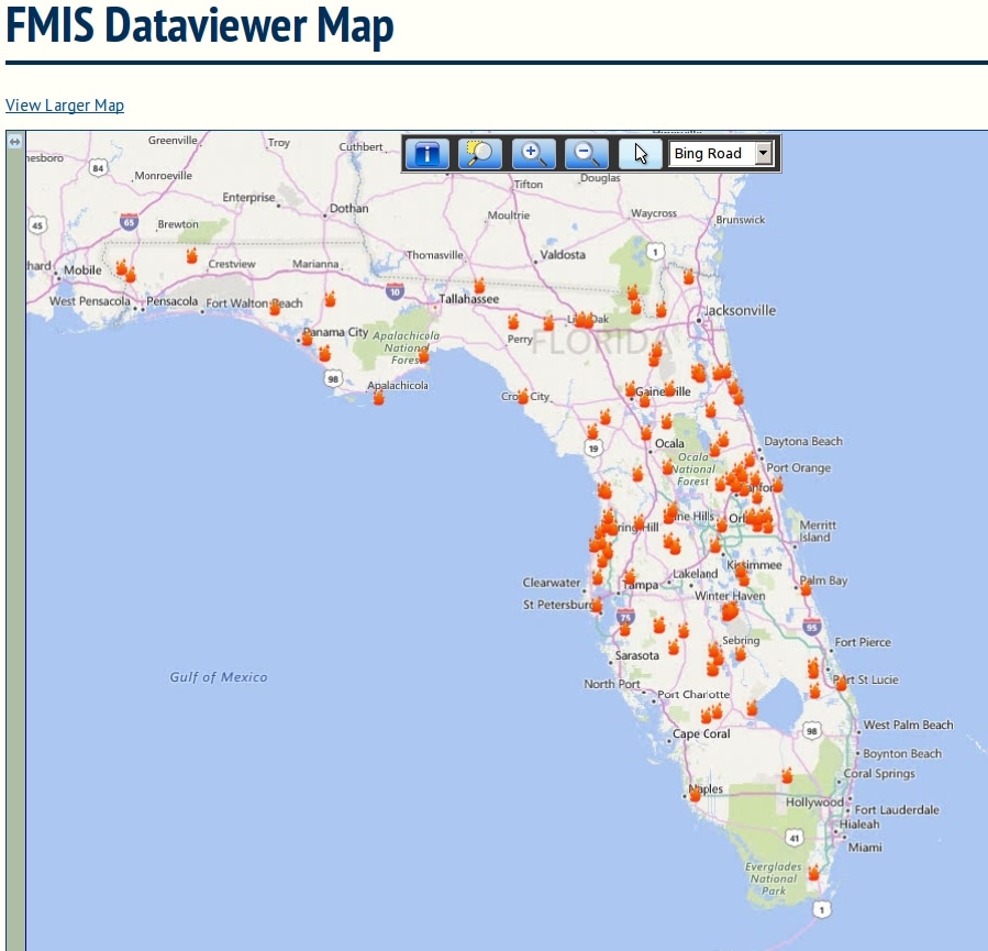
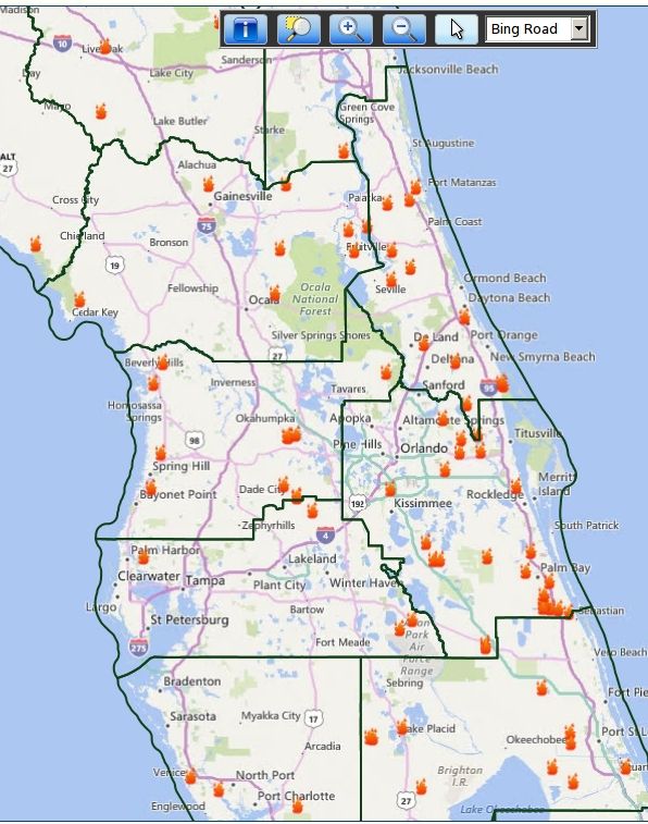
A new U.S. Drought Monitor Map was released this morning. with some errors. Below is the correct version. It's still very dry in North Georgia, Upstate South Carolina and Western North Carolina. Florida has dried out considerably froma dry, hot March. The recent storms brought a lot of lightning. At least four homes were hit in Florida, one in Melbourne. The lightning alsostarted brush fires including the ones clustered around South Brevard in the Micco area and the one near San Filippo Dr in Palm Bay. Friday is expected to be a higher fire risk day across much of Florida as the winds pick up and the humidity falls. The map on the left is the FMIS Data Viewer Map.
  Global Tropics
15S ERNIE
  14P 14P
Sunday, April 2, 2017 had a High chance of severe weather. Monday's convective outlook was an Enhanced Risk of severe potential. Tuesday, flooding rains are occurring across Northern Florida, there is also two areas with enhanced risk. Wednesday (4/5) the severe weather is expected to increase with Moderate risk across much of the Southeast, northward along and west of the Appalachians into the Ohio Valley, Wednesday through Wednesday night. This is expected to include supercell development with a risk for tornadoes, some of which could become strong and long-lived, particularly across parts of the Southeast.
There has been two fatalities, a mother and daughter. Their mobile home was blown off it's foundation. One tornado has been spotted by a police officer in Kerr, TX. The second was in RAPIDES LA. There was a roof blown off and metal debris flying around. There was a long tracking tornado in central Louisiana with and injury injury in FRANKLIN LA when a tree fell on a car. Other tornadoes were spotted across Louisiana. Wind has damaged many trees including Pecan. The second story of a structure was damaged and a large metal structure was destroyed in Kendall, TX. Some horse barns were hit, at least one destroyed, a shop lost it's roof, a Sonic sign was destroyed, another person was trapped in their car. 4/3 SPALDING GA was hit by a tornado, several homes were destroyed, people were trapped and rescued. SCHLEY GA had metal in the trees. There was also an injury there when a tree fell on a home. MONROE GA had many trees down, some on houses with homes damaged, one destroyed, the family was rescued. Largest hail has been 1 3/4inches is different locations in Texas, Arkansas and Mississippi. The larger hail seemed fairly consistent with this storm until Monday when the largest hail size was 1 1/4inch in both Georgia and Kentucky. Moday there was alot of wind damage from Arizona to Florida but mainly in Georgia with alot of trees vs power lines. There was a trampoline in the power lines and some structures destroyed. There was another fatality in UNION SC where a mobile home was blown into a road and destroyed. There was two injuries in COLUMBIA GA when a dock failed at a marina. This outbreak is continuing on so summarizing damage by the day now: Tuesday 3/4/2017 Missouri was the worst hit. A tornado hit a school in Goodman, MO. Preliminary survey showed EF-2 damage. Wind was a factor mainly in MO, OK, KS, TX, AL and FL. Mostly tree damage and trees into power lines. A chicken barn was destroyed as was a carport. There was some homes damaged and roofs lost. Highest clocked winds were 80mph in Goodman, MO. Hail was wide spread, the size of which was getting bigger by the end of the day. There were several 1 3/4" reports from Alabama.   
GLOBAL TROPICS
93P

|
Current Tropics and Weather News..
Archives
January 2022
|


 RSS Feed
