|
Welcome to Skyepony's Weather Blog.
|


|
Weather was wild in various parts of the United States again today. Two death occurred in the Northeast. One in Connecticut the other New York. Both were in a car when a tree fell on it. Three people were injured from falling branches and another kid was injured when a dugout roof collapsed. Damage was scattered from Texas to the Northeast. There was two tornadoes, one in NY the other IL. Ties for big hail at 2 3/4" between TX & NY. Lots of wind reports. Many trees blown down, power outages and roof damage. A few buildings were reported as destroyed. Roof loss occurred to homes, warehouses, a church and a Duncan Donuts. 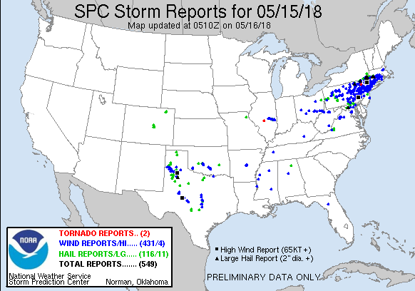 Published on May 15, 2018 ***NOT FOR BROADCAST*** Contact Brett Adair with Live Storms Media to license. [email protected] Tornado watch: Rotating cloud spotted in Connecticut MassLive
Published on May 15, 2018A funnel cloud rotates above Lake McDonough in Barkhamsted, Conn., as an intense thunderstorm moves toward Southern Massachusetts on May 15, 2018.
Comments
Weather patterns are changing as a mid-level low is taking shape in the Eastern Gulf of Mexico and an inverted trough approaches from the Atlantic. This should eventually feed moisture to the north to meet up with the precipitation still streaming through the Northeast on the jet stream. The Eastern half of the USA is looking at a lot of rain coming this week. For Florida the rain may continue on into a second week as some models are hinting at an early start to hurricane season.
It's time to pick-up outside and clear drains. Some areas along the East Coast of Florida are expected to have over 7 inches of rain in the next week. It is also a great time to get in the gardens to pull weeds, fertilize and plant. With all the rain ahead a lot of growth is about to happen and once this all clears out in a few weeks it will be about into June and Meteorological Summer heat. Plant that summer garden now! Leaving some self updating graphics for the rain event. Refresh or revisit this page to see the latest.
Seven Day Rain Forecast...................................................Today's Forecast
  Quantitative Precipitation Forecasts  CIMSS Water Vapor with Color Background Wunderground United States Radar  NHC Five Day Graphical Weather Outlook Wunderground Radar  NWS Melbourne NWS Melbourne
Horses rain dance SmokeyZN
Published on Sep 17, 2011My horses doing the rain dance under the sprinkler 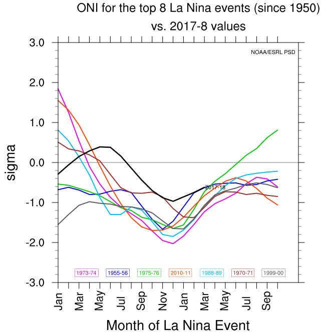 Figure1: Oceanic Niño Index: 3 month running mean of ERSST.v4 SST anomalies in the Niño 3.4 region (5°N-5°S, 120°-170°W) Calculated from the ERSST V5 (at NOAA/CPC). Credit: ERSL/NOAA The graph above compares this past La Nina that has just ended to other recent La Nina events. 2017-18 is pictured in black. It was a weak La Nina but clusters well with other events ending in the spring. Below is a look at these similar years tropical storms histories (depressions - tropical storms - hurricanes - major hurricanes). 1956 15-12-4-1 1971 22-13-6-1 1974 21-11-4-2 1976 23-10-6-2 1989 15-11-7-2 2000 19-15-8-3 2011 20-19-7-4 The average storm numbers for the Atlantic are 10.1 named storms, 5.9 hurricanes and 2.5 major hurricanes. So these years listed shows well above average tropical cyclones, slightly elevated number of hurricanes and average number of Major hurricanes. Also throwing out there a year seen mentioned a lot in the broken records and similarities, especially for the Northeast. It was a neutral year coming off an El Nino. 1907 5-5-0-0 Looking at Tornado numbers through March.. There is some research showing low spring tornadoes can end in more hurricanes hitting land. This spring there has certainly been less tornadoes than usual with only 62 preliminary reports through March. Other years with similar numbers include: 1952 11-11-5-2 1953 14-14-7-3 1955 13-13-10-4 1959 14-14-7-2 1963 9-9-7-2 1979 26-9-5-2 1989 15-11-7-2 1992 10-7-4-1 1993 10-8-4-1 1995 21-19-11-5 1999 16-12-8-4 2004 16-15-9-6 2005 31-28-15-7 Though the numbers here were average to above average, the big take away seems to be the track maps showing the much higher likely hood of landfalls on the Gulf of Mexico/Florida regions with the East Coast also showing a somewhat raised risk. 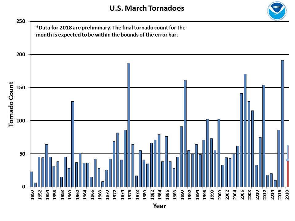 Before coming up with seasonal forecast numbers we'll need an in depth look at the global tropics scene. That will be another blog..
Cited references.. NOAA National Centers for Environmental Information, State of the Climate: Tornadoes for March 2018, published online April 2018, retrieved on May 12, 2018 from https://www.ncdc.noaa.gov/sotc/tornadoes/201803. Cave Discovery Shows How Humans Survived the Extreme Weather 78,000 Years Ago A large cave system was found in Southeast Kenya, located 15km from the coast. It's name is Panga ya Saidi. The cave system housed homo sapiens at least as far back as 78,000 years ago. It was in a more stable climate area where people could feed off the woods and animals in the area. It looked inhabited all throughout the time of the Toba super-eruption 74,000 years ago which caused major weather disruptions and die offs of people and other species. Many artifacts were found dating from the Stone Age to the Iron Age. The cave reveals a point around 67,000 years ago when homo sapiens began on more technical endeavors. It was the dawn of crafting small useful items. More here..  At the Kenyan site the scientists found several different symbols of tools and culture of primitive humans. These are, from left to right: Worked red ochre; bead made of a sea shell; ostrich eggshell beads; bone tool; close-up of the bone tool showing traces of scraping Carnies Convicted in Bounce House Wind DeathBeen following this trial in Essex over a seven year old girl's death. The carnival owners were taking down inflatables as a storm blew up. The girl wanted to bounce just a little bit longer. The carnival owner agreed and then the wind carried the bounce house down a hill. It stopped when it hit a tree. William Thurston, 29, and his wife Shelby Thurston, 26, were convicted of gross negligence manslaughter. Flooding Continues There is two invests out there 97W & 90E. The tropics overall haven't been very active; the flooding, landslides and such continue on. Swirl Watch On
Issued a Haircon Advisory on the blob approaching Florida a few days ago. Models are coming into more and more agreement this may rain on Florida's weekend. GEOS-5 shows it being no worse than a possible Tropical Depression but may put a damper on Sunfest..

High Winds to the North
High winds tore through from Michigan to Toronto and through the Northeast disrupting power, removing shingles and damaging trees. Over 300,000 people are without power. Atleast two deaths and two major injuries have occurred so far.
Wind storm leaves path of destruction in Toronto CityNews Toronto
Published on May 4, 2018A look at some of the destruction caused by the wind storm Friday afternoon in Toronto. Nitish Bissonauth speaks with a passenger who was on a flight that made a harrowing landing at Billy Bishop. |
Current Tropics and Weather News..
Archives
January 2022
|
 RSS Feed
