|
Welcome to Skyepony's Weather Blog.
|


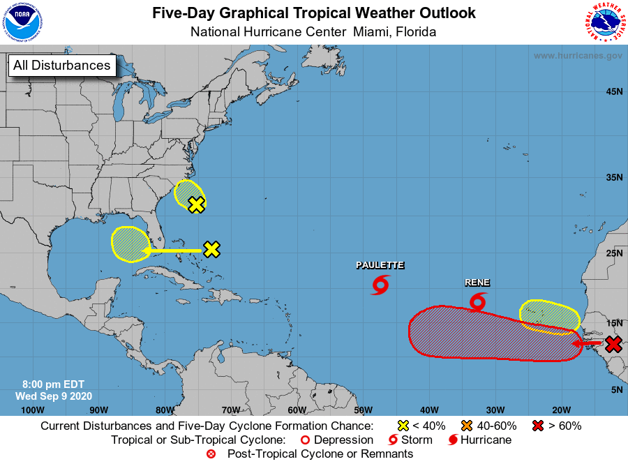 Approaching the height of Hurricane Season 2020 the tropics are active. Though the upper levels aren't too conducive for monster storms and mad divergence aloft there is the edge of a Kelvin Wave passing thru the Main Development Region. Paulette and Rene are both Tropical Storms. Paulette and the red X over Africa have the best chance at becoming hurricanes, Rene could also become a hurricane. As to where these go the models are undecided from run to run and have rarely agreed with each other. With multiple storms so close and other maybe storms trying to form, a higher level of uncertainty of forecast is in play. The red X on Africa probably has the best chance of making it across the Atlantic to landfall. Less likely, Paulette or Rene could curve out and circle back around too. Paulette currently has Bermuda in it's cone. The invest off South Carolina 94L, continues to look less likely to develop. It's recon for the afternoon was cancelled. 94L is running out of time, and is expected to be over Eastern North Carolina by Thursday afternoon. The area that has been over the Bahamas has upped it's odds to develop in the next five days to 20%. It is expected to cross Florida on Friday. 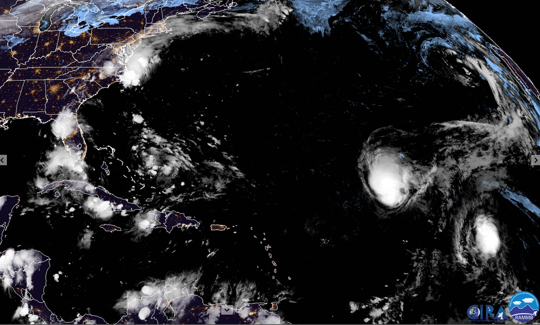 Disaster Days of 2020 Rages On China Flood Surpasses 1998
Comments
Comments at YCC Expected to Open Around July 15th Dr Jeff Masters published a great dust update blog at Yale Climate Connections. He also gave us a statues update for the community move to a new comment section at YCC: Comments section expected to be available around July 15. Their developer got pulled off to another project--redoing the web pages for one of Yale's departments that just changed their name. Blob Watching Dust has hampered the tropics for the most part. National Hurricane Center isn't expecting any tropical activity for the next five days. Being hurricane season with the models missing a lot of upper air data from airplanes down due to corona, watching those model hints and convective blowups. Was watching a blob off of Florida this morning that was attached to an area of interest that was marked with a yellow X by National Hurricane Center. it has had some model support to pull together a weak brief low off the Mid-Atlantic states. That area was disrupted by dust, plus shear from the upper level low over the Northeast and was dropped by afternoon. The evening blob to watch is what was the north end of a Tropical wave that broke off and has become a surface trough near 25N 55W. It looks tenacious..especially while battling 40kts of shear. The shear is not expected to let up soon, giving this blob little chance. Flooding from Midwest to Northeast, Some in the South too. The previously mentioned deepening upper level low over the Northeast has been fed by moisture that caused flooding in Western Wisconsin that claimed one life where several had driven into a flooded roadway and were swept into a creek yesterday. There was another car in a creek in Tennessee. Lightning in Minnesota. Trees down in New York City. There was flooding in Kentucky. This hospital in Boston had its basement overwhelmed by run-off and was forced to move patients and close. Stay Safe Everyone!
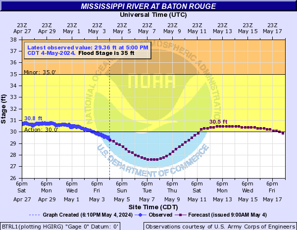
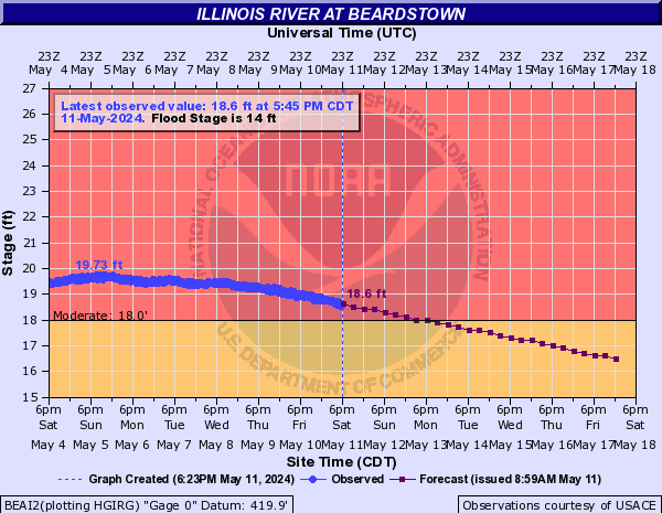
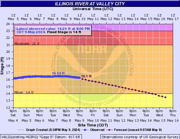
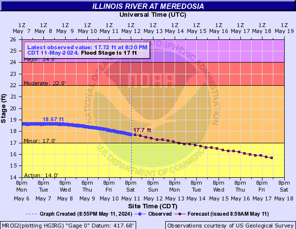
Heavy rain and spring melt is coming together in the Mississippi and Illinois River. Sections of both rivers are flooding. The Mississippi record at Rock Island broken. More may fall as the daily severe storms rain on.
These river gauge graphic are in real time. Refresh page for latest. To see river gauges across the United Statescheck here.
Overnight we saw continued flooding in Saudi Arabia. Tobago was also impacted by heavy rain that resulted in flooding and landslides.
Flooding in Jeddah , 21.11.2017 جدة | Наводнение в Джидде (Саудовская Аравия)
Local Wet Thanksgiving Week
East Central Florida is in for some weather this week. The rain today is just a taste of what's coming. Already a more than anticipated..there has been a little thunder and some puddles, overall it's been great sleeping weather. Models have been torn about a weak low to tropical storm forming in the Gulf of Mexico & coming over Florida for days. The timing now seems a little later with the worst weather over Florida Friday or Saturday.
|
Current Tropics and Weather News..
Archives
January 2022
|

 RSS Feed
