|
Welcome to Skyepony's Weather Blog.
|


Comments at YCC Expected to Open Around July 15th Dr Jeff Masters published a great dust update blog at Yale Climate Connections. He also gave us a statues update for the community move to a new comment section at YCC: Comments section expected to be available around July 15. Their developer got pulled off to another project--redoing the web pages for one of Yale's departments that just changed their name. Blob Watching Dust has hampered the tropics for the most part. National Hurricane Center isn't expecting any tropical activity for the next five days. Being hurricane season with the models missing a lot of upper air data from airplanes down due to corona, watching those model hints and convective blowups. Was watching a blob off of Florida this morning that was attached to an area of interest that was marked with a yellow X by National Hurricane Center. it has had some model support to pull together a weak brief low off the Mid-Atlantic states. That area was disrupted by dust, plus shear from the upper level low over the Northeast and was dropped by afternoon. The evening blob to watch is what was the north end of a Tropical wave that broke off and has become a surface trough near 25N 55W. It looks tenacious..especially while battling 40kts of shear. The shear is not expected to let up soon, giving this blob little chance. Flooding from Midwest to Northeast, Some in the South too. The previously mentioned deepening upper level low over the Northeast has been fed by moisture that caused flooding in Western Wisconsin that claimed one life where several had driven into a flooded roadway and were swept into a creek yesterday. There was another car in a creek in Tennessee. Lightning in Minnesota. Trees down in New York City. There was flooding in Kentucky. This hospital in Boston had its basement overwhelmed by run-off and was forced to move patients and close. Stay Safe Everyone!
Comments
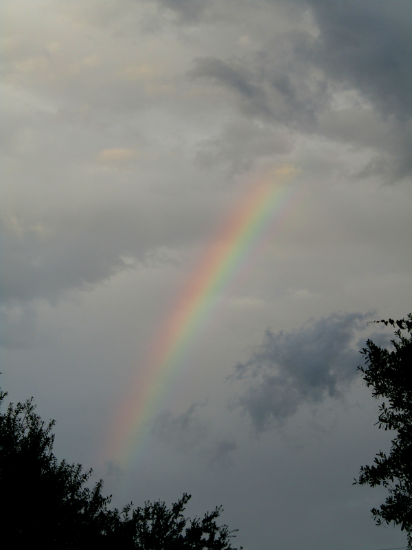
Year of the Rainbow
2020 has had one colorful side, the amount of rainbow sightings seem to have increased dramatically. Saw another mention of the trend today by Ski Bum who coined it being the Year of the Rainbow. Been meaning to write this blog since one of the spring tornado outbreaks when stunning videos of rainbow after rainbow, even in unexpected places kept appearing. When I asked Bob Henson about the rainbows and tornadoes event he replied, ..."this is the first time I've ever seen so many in one event. Probably just a function of how clear it was behind the line of storms."
With Corona lock down came a noticeable drop in air pollution. It has been realized for some time that air pollution can make rainbows appear much less vibrant or look more like white fog bows. The pollution particles in the raindrops don't scatter light into colors as well as pure rain does. Some studies and theories were brought forth when Seoul couldn't make a rainbow for over three years in the late 1990s. Pollution seems to be the obvious cause dulling or washing out colors depending on severity, but more research in this area could be done including gauging the sort of pollution present by the width, vibrancy and depth of color in rainbows. 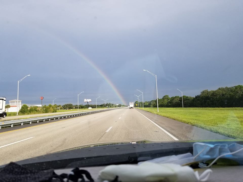
Image 1: Today's Rainbow picture is titled, "Headed South, Looking For the Pot of Gold. Image credit Curtis Musselman.
Dust Watching
Dust Cams.. Refresh page for newest images.
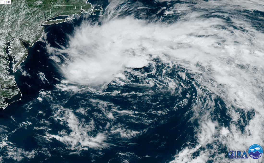
WunderCam 1: garybyamCAM1, Pensacola Beach, FL WunderCam 2: WeatherSTEMCAM13, Greenville, FL Comments on the Last Cat 6 Blog Remain Open For Now The blog comments at Cat 6 at WeatherUnderground did not close on Monday 06/22/2020. There has been much uncertainty about when the comments will close, and Monday was the earliest expected. There is hope the comments there will stay open til at least Yale Climate Connections blog comment section is ready. Dr Jeff Masters posted in Cat 6: "As far as I know, the comments for this post will remain open for commenting indefinitely." And..."Bob and I think that IBM will do minimal maintenance on the WU site after today, which may mean the comments here will remain open. At some point, they will have to unlink the Cat6 blog from the main menu, though, and perhaps then they will see fit to close comments here. BTW, I have a new post coming on the African dust at YCC. There is a long lag between when I write something and when it goes up right now, though, so I'm not sure when it will appear. Because of that lag, I won't be posting on STD 4. I expect the lag to be gone in week or two." Dr Jeff Masters' new post is up and can be found here. Subtropical Depression Four Becomes Tropical Storm Dolly Subtropical Depression Four has formed several hundred miles to the Southeast of Massachusetts and is expected to continue to move away from land. The Forecast Track gives 04L a chance of becoming a Tropical Storm tonight and them weakens it to 30kts thru the next 2 1/2 days. Tuesday Update: STD 4 became Tropical Storm Dolly and is located several hundred miles Southeast of Nova Scotia at 39.4°N 61.7°W. It is moving ENE at 13 mph. The Min pressure is 1002 mb with Max sustained of 45 mph. NHC still expects it to become extra-tropical on Wednesday. Much Flooding Globally So much flooding is going on that it's hard to pick just one video. So many with buildings and vehicles submerged or washed away. Areas impacted include: Sumatra, Turkey, China, Tibet and Belle Isle (Detroit). One video that stood out was from China demonstrating the sort of perseverance and forethought it is going to take to deal with these extreme floods. This time lapse video shows how soldiers constructed a 222-meter-long temporary bridge over the Jinsha River in supposedly 40 minutes. WUnderCommunity on the Move
95L Off the Mid-Atlantic Coast
95L is a well defined, multi-vorticity, non-tropical low that is currently 300miles Southeast of Cape Cod, Massachusetts. National Hurricane Center is giving this a 40% chance of becoming a sub-tropical storm by as early as tonight. Some places along the Mid-Atlantic Seaboard are expecting a surge higher than Highest Astrological Tide. A few places, including Washington DC can expect a surge of nearly 3 foot above Mean Sea Level.
This buoy is a little north of where 95L is currently located and in the area where 95L is expected to linger. Pressure is steadily dropping. This buoy graphic will update when the blog page is refreshed.
NOAA buoy 44008 African Wave Brings Chaos to Benin
Snapped the view from EUMETSAT yesterday showing the blow up of rain from a tropical wave over Southern Benin. That is the tall, skinny country just west of Nigeria.
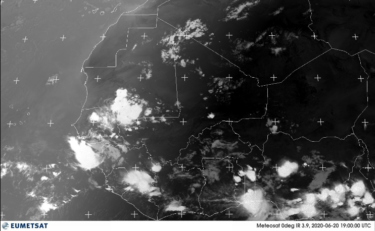
The flooding is being blamed on those with influence on one side of the road sending all their water via a new expensive taxpayer funded moat diverting the water into the poorer district. The heavier rains are blamed on climate change.
NASA's S2S_2.1 has it's June forecast together and out. For more on what goes into this model, check here. Sea Surface Temperature Anomaly 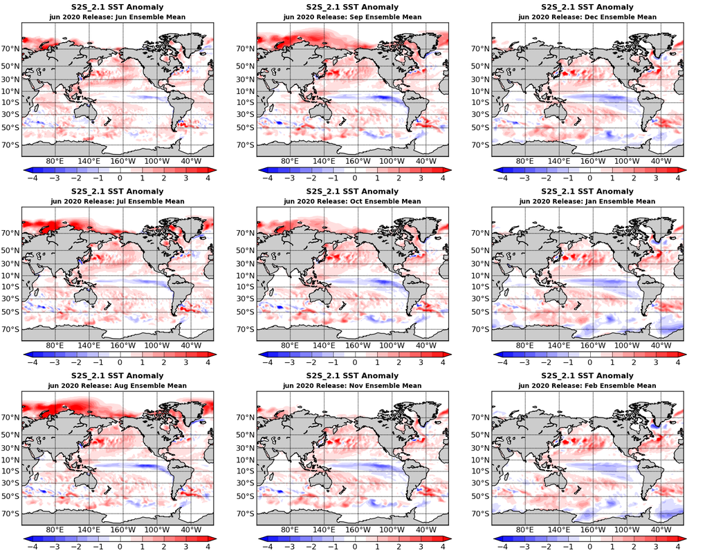 NASA Goddard's S2S_2.1 starts the forecast off with overall warm oceans. It's showing Earth on that cusp of a La Nina with cooler equatorial waters developing in the Pacific. The warmest departures from normal are notable around the Arctic this summer with more ice loss occurring north of Russia. Out in the other oceans warm emanates east from Japan, South America and along the Gulf Stream (east of the United States). The water in the Gulf of Mexico, Main Development Region and around Florida looks warm through September. Precipitation Anomalies Select from the bottom of this picture section to view Global or North American Precipitation Anomaly Forecast. For North America S2S_2.1 starts out dry in the west and wet in the east. October shows a big change with most the south having a dry month as the pattern flip flops. Globally India may have a few more months of monsoon weather. East Pacific may try and get a few storms in September. Philippines may have less storms than normal until November. Temperature at 2 Meters Anomaly Select from the bottom of this picture section to view Global or North American T2M Anomaly Forecast. Starts out average to below average Temperature 2 meters above ground for much of the Eastern United States with only mild warms elsewhere. This pattern persists thru September when most of North America becomes exceedingly warm thru the Fall. Globally the Arctic takes the real heat this summer. Comparing Various La Nina Models  Fairly good agreement among the models with GFDL going it's own way to weak El Nino Conditions. The rest call for a weaker La Nina to develop and maintain thru Hurricane Season. Sea Ice Concentration Forecast 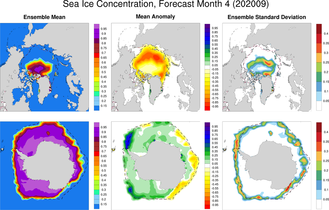 NASA's S2S_Forecast to be one of those Earth's attic is on fire years, including dramatic sea ice loss.
Which is nearly a given being 2020. Stay safe Everyone! 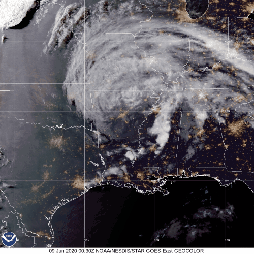
Tropical Depression Christobal is moving NNW at 17 miles per hour. It is currently located about 10 miles West of Little Rock Arkansas. Maximum winds are 30mph. Central pressure is 994mb. A Flash Flood Watch is in effect nearly along all the Mississippi Valley Region. A Gale Warning is in effect for Lake Michigan.
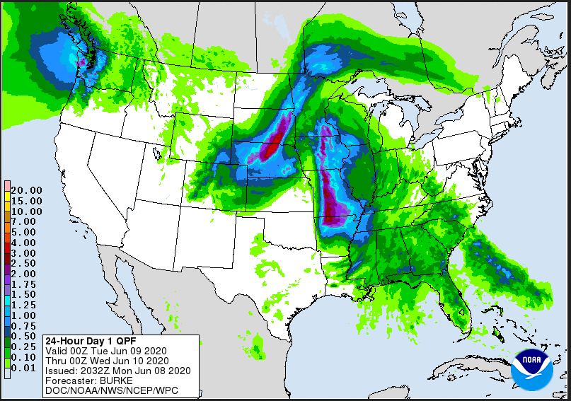
Much more rain is forecast to fall from Christobal as a front sweeping the country brings even more. Christobal is expected to strengthen slightly as it turns extra-tropical.
Cristobal damages Biloxi's pier. Part of it comes ashore a 1/2 mile away.
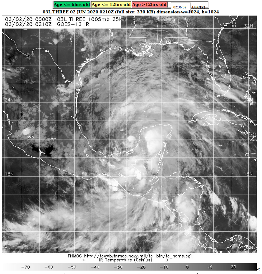 Tropical Depression 02 in the Eastern Pacific turned into Tropical Storm Amanda and then quickly came onshore Sunday morning bringing devastating rains to El Salvador where most of the at least 20 deaths occurred. Guatemala and Honduras were also impacted. According to Carolina Recinos an aide to the President, Amanda dropped 10% of the yearly expected rainfall on El Salvador. After a little more than a day of gyrating and growing overland, Amanda remnants (then 93L) stepped off into the Bay of Campeche and quickly began to organize. It has now been declared Tropical Depression 03L. The early track models were a bit all over the place. Late track models favored north to north/northeast, though some took it back to land. Models don't agree on much other than if it gets away from land it may pick up some speed as it tracks thru the warm Gulf of Mexico. 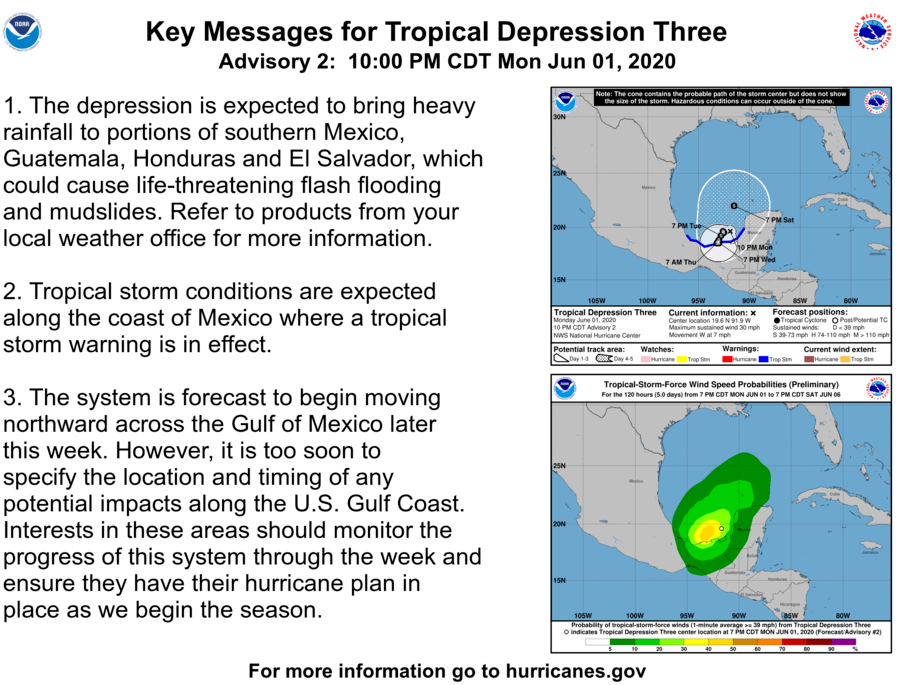 Figure 2. National Hurricane Center Key Messages for Tropical Depression 3. The flooding in El Salvador from Amanda is a continuation of the scary step up we've seen recently in the most extreme flooding events. And the Occasional Horse Video... Some horses have been making it out to the protests and riots. A few their owners rode, many more were brought for the police to ride and use for crowd control. This was the wildest horse video of the lot when a rioter rides off on a police horse. Lucky he's riding with waze, warning him of the dangers ahead. |
Current Tropics and Weather News..
Archives
January 2022
|
 RSS Feed
