|
Welcome to Skyepony's Weather Blog.
|


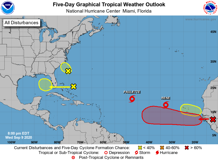 Approaching the height of Hurricane Season 2020 the tropics are active. Though the upper levels aren't too conducive for monster storms and mad divergence aloft there is the edge of a Kelvin Wave passing thru the Main Development Region. Paulette and Rene are both Tropical Storms. Paulette and the red X over Africa have the best chance at becoming hurricanes, Rene could also become a hurricane. As to where these go the models are undecided from run to run and have rarely agreed with each other. With multiple storms so close and other maybe storms trying to form, a higher level of uncertainty of forecast is in play. The red X on Africa probably has the best chance of making it across the Atlantic to landfall. Less likely, Paulette or Rene could curve out and circle back around too. Paulette currently has Bermuda in it's cone. The invest off South Carolina 94L, continues to look less likely to develop. It's recon for the afternoon was cancelled. 94L is running out of time, and is expected to be over Eastern North Carolina by Thursday afternoon. The area that has been over the Bahamas has upped it's odds to develop in the next five days to 20%. It is expected to cross Florida on Friday. 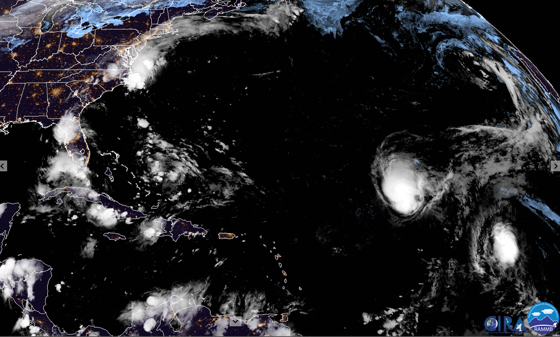 Disaster Days of 2020 Rages On China Flood Surpasses 1998
Comments
Tropics GPM (Global Precipitation Measurement) passed over the northeastern U.S. on Oct. 29 at 8:36 p.m. EDT. The approximate location of the storm's center at the time of the GPM pass is shown with a large red "L". A large area of intense rain was located in the Atlantic east of the low's center. GMI estimated that rain in that area was falling at rates of greater than 2 inches (51 mm) per hour. The highest storm tops in the system were revealed by DPR to reach heights of about 5.6 miles (9 km). Credits: NASA/JAXA, Hal Pierce The freezing heights could also be seen from this GPM pass and they had good slope. The freezing height averaged 2.1miles high but was just 1/2 mile up over southern Quebec & higher than 2.9 miles well east over the Atlantic Ocean. 94L is no more, fell apart and other weather features got involved. May see 95L and possibly a depression out of that disturbed area in the middle of the Atlantic. 96W is now 28W. 95W and 99B struggle on. China Launches a Large Ship for Installing Wind Turbines
With the Madden-Julian Oscillation (MJO) camping in the area, looks like no break for the hurricane weary. 90L has been declared in the Southwestern Caribbean. Early models show that developing into a possible storm for the Gulf of Mexico over the next several days. Another area of interest is just south of Florida, being sheared well back into the Bahamas. Not many models are developing this but it looks gamely and could affect the track of 90L making the current model scenarios more uncertain.
Locally Brevard County, Florida is under a Gale Warning. Watch out for those widow makers..more rain too. 90E is active in the Eastern Pacific. It may get absorbed into the Atlantic drama or try and form as it heads up the coast. 
2o1oo's Wundercam
St Barth Webcam
 Published on Aug 17, 2017 by: NPI Productions
Hurricane Gert sent a fun 3-4 foot swell and every surfer in Florida was on it. Almost thought we were at lowers for a moment! |
Current Tropics and Weather News..
Archives
January 2022
|
 RSS Feed
