|
Welcome to Skyepony's Weather Blog.
|


|
Isaias consolidated overnight and got named. People in Puerto Rico were reporting winds close to hurricane strength. Watches and warnings are up as people scramble to ready for this storm.
Much of this blog is self updating when the page is refreshed, except for the picture slide that will continue to be added to. This blog is still a work in progress. Below is an Isaias slide show of saved imaged and gifs. From left to right is newest to oldest.
NASA launched the Rover Perseverance toward Mars Thursday. It should take about 7 months for it to travel there. The return of Bob & Doug and planned splashdown in the Atlantic from the Space Station may be delayed due to Isaias.
Comments
Tracking PTC9 as it approaches the Antillean islands. brohavwxCAM2 for Bridgetown looks to have lost power about 6 hrs ago. North of there, 2o1ooCAM in Sainte-anne, grande-terre still looks functional. It should get hit even harder.
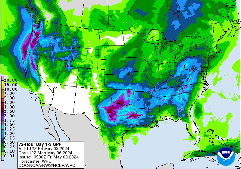
Looking at average 24hr model error for PTC9, overall it is atrocious. UKMET is far outperforming the rest. After a few fairly bad days it is recovering with 88 nautical miles of error on day 4. Looks like models overall preformed badly for a bit, really increasing 2-3 day error. Some of this error is timing in that the storm moved faster than expected. The TAB models are losing, the worst being TABS, with 4 day error at 1194.2nm. There is still much uncertainty in the track of this storm. Embedded graphics below that self update when refreshed. Potential Tropical Storm 9
 
Adding a slider for archived PTC9 pics and gifs.. Left to right is newest to oldest.
Wundergrounders to YCC Move is On
Yale Climate Connection has opened a comment section for us at Jeff Master's and Bob Henson's Eye of the Storm Blog. Join us there for the ongoing discussions or comment here if it's more fitting or you need help getting in there.
Tropics are fairly fluid at the moment so put together this somewhat self updating blog. Refresh to see latest graphics, satellite views and what not..
In the Atlantic 90L made landfall on Texas & was decommissioned. 91L, in the Gulf of Mexico is now 08L. It is still a t PTC status, nearly a depression that is expected to possible hit land soon as a tropical cyclone. Models are trending west toward Texas, they make a Tropical Storm of it. 99L is now Tropical Storm 7 and was named Gonzalo Wednesday morning. it is expected to become 2020's first Atlantic hurricane. In the EPAC 08E is now Douglas and may hit Hawaii as a weak hurricane or tropical storm.. 07E is gone. 92S is in the Southern Indian Ocean headed Southwest.  08L Hanna  AlanGuggenheimCAM3 South of Corpus Christi, TX on the barrier island.
*******************************************************************************************
07L Tropical Storm Gonzalo 
********************************************************************************************
It's time to finishes prepping for this hurricane season, if you already haven't. Local Brevard County Emergency Management stressed adding corona preps to your hurricane kit, extra masks, soap, hand sanitizer and cleaning supplies. ******************************************************************************************** Tropics came to life. In the Gulf of Mexico, 90L is nearing Texas. This is the tropical wave from last blog. There is also 99L in the middle of the Atlantic Ocean, down in the Main Development Region. In the Eastern Pacific 99E is now 07E, 08E has also formed. The Southern Hemisphere is bringing an off season invest 92S near the equator in the Indian Ocean. National Hurricane Center has three places tagged for possible development in the next two days. 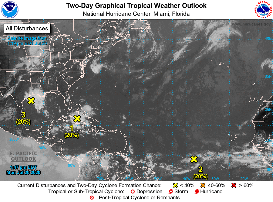 90L Weak low pressure has formed, 1012mb with a surface trough extending south. It is expected to push on shore in Texas Tonight or tomorrow. Some gusty winds are possible. Rain is not looking all that heavy so far. Sabine Pass, TX is expecting the sea to come up to near 2ft above Mean Sea Level. Galvaston is in the red as well. 99L 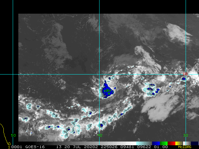 Wunderground Happenings Yesterday the update on Grothar was he is back at home, cancer-free and resting.
Bob Henson wrote a blog Baked by midsummer sun, Arctic sea ice could face worst losses on record at Eye on the Storm, Yale Climate Connection. No tropical cyclones are expected by NHC in the next 5 days. There are swirls to watch in both the Main Development Region and the Gulf of Mexico. Globally the only invest out there is the recently designated 99E. 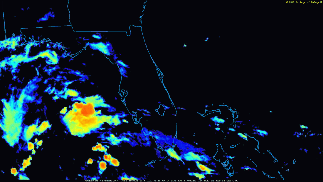 Figure 1. Tropical Wave passing through the Gulf of Mexico.
This quiet period seemed like a good time to reflect on how models did forecasting the storms so far in the 2020 Hurricane Season. Tropical Storm Arthur the models were run out 4 and five days. ECMWF ensemble models were only run out 2 days and though showed promise aren't being considered. Overall most models did bad with this storm with more than 100nm error at day 3. UKMET won this storm with 81nm of error at day 3 and 62nm of error on day 4. NAVGEM also showed skill with 66nm error at day 3 and 72nm on day 4. Most the models did good on strength except the LGEM model. Tropical Storm Bertha was short lived. Most models only had 24hrs to run on this storm. Clear winner was EGRR, a variation of the UKMET model. It had 7.6nm error at 24hrs. The next closest in a pack with anywhere between 31 and 39nm error from best to worst was the HWRF, CMC, ECMWF and TVCN. HWRF won intensity with 1.2kts of error. Tropical Storm Cristobal had out to 5 days run on about all models. Most models did poorly with over 100nm error at 3 days. The CTC suite out-preformed the others. CTCI had 58 and 92nm of error at days 4 and 5. MYOC which is a forecaster created census took third with 122nm error at day 4 and 17nm error at day 5. Models were not all that impressive on strength except UKMET, HMON, CTC and IVCN. Tropical Storm Dolly, most the global models had 3 days to run on this storm, most storm specific models had 2 days or less and aren't being considered. This storm the models overall struggled. NAVGEM had 65nm error at 2 days and 42 at 3days. HWRF had 97nm of error at 2 days and 30nm error at 3 days. Neither were very impressive but they far out-preformed the rest. HWRF did well on intensity, the rest did pretty bad. Tropical Storm Edouardo was a short lived storm. Most of the models only had two days to run on it and did terrible overall. Winners are HMON followed by UKMET with errors at day two of 53nm and 60nm at day three. The better forecasters of strength for this storm are ICON, NAVGEM and CMC. Tropical Storm Fay on average had the models run out 4 days. Model error showed HMON the winner with 16nm error at 3 days and 54nm at 4. GFS ensemble number 20 was not to far off with second. AEMI was third with 78nm error at 4 days. CEMN had 91 & 90nm error at 3 & 4 days respectively. HMON also won strength forecast with 0 error on day 4. So far it is looking like UKMET, HMON, NAVGEM and HWRF are on top for forecasting storm position. HWRF and HMON are the better preforming strength models. Tropics
Atlantic Blob Watch Today's blob to watch is coming off of Africa. NASA's GEOS-5 model shows this lingering at the African Coast for days then becoming a weak Tropical Depression before running into South America. 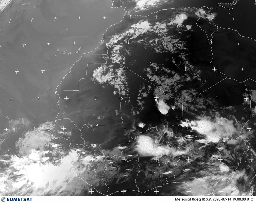 South Indonesia Flood and MudslideA horrid flash flood hit in Indonesia's South Sulawesi province Monday night. At least 15 are dead with many others missing. A torrent of water caused massive landslides when three rivers overflowed. National Disaster Mitigation Agency spokesman Raditya Jati said, "The provincial road is covered in mud and that blocks access to the main command post and the affected areas". Thousands of homes were covered in mud, more than 4,000 residents of six sub districts in North Luwu were affected. siti nurjanah
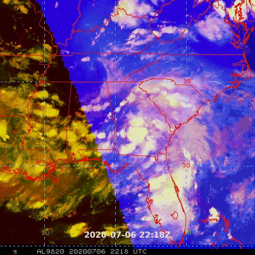
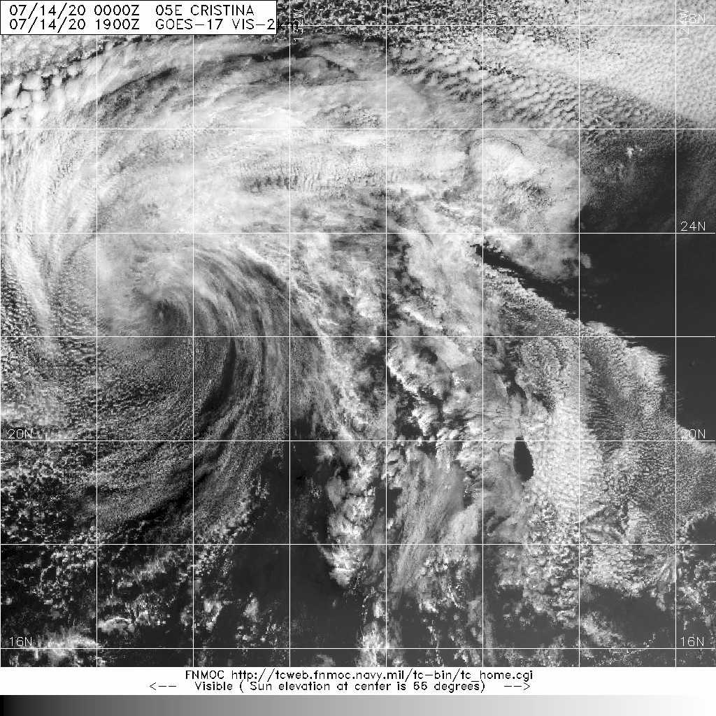
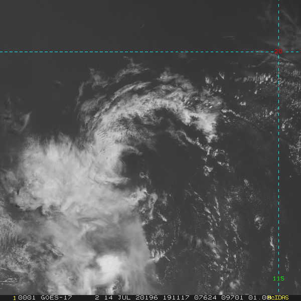
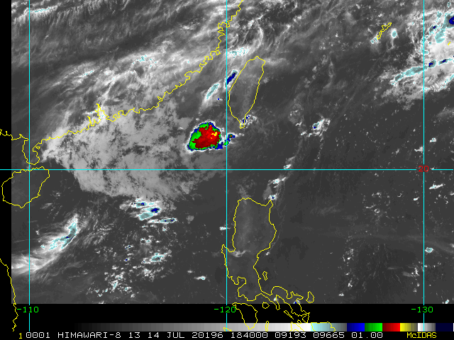
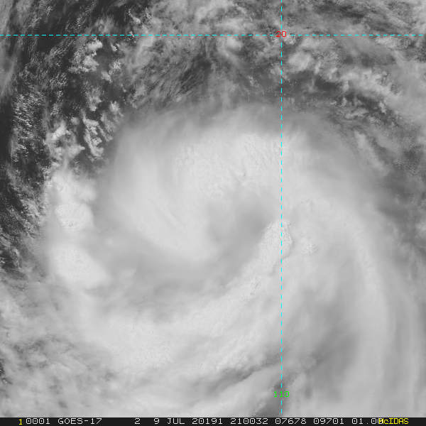
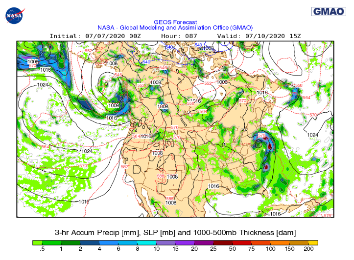
(translated from Indonesian) Floods hit North Luwu, South Sulawesi, early this morning. location of flash floods in the district of Masamba and kec. Babunta (Radda Village) Kab. Luwu Utara, South Sulawesi. This flash flood is a shipment of water from a number of neighboring regions. The reason is because of the high rainfall intensity in the Luwu Raya region over the past few days. The situation this morning (14/7) around the Syuhada Mosque, Masamba after being hit by flash floods accompanied by mud on Monday night (13/7) was not spared from the lunge of floods and mud. .. Not much to watch in the Atlantic today. Most prominent feature was this blob north of Puerto Rico from a tropical wave. It lacked model support. Any decent conditions it had were expected to wain by late Sunday and with it goes the wave's convection, leaving a defined yet fading circulation. 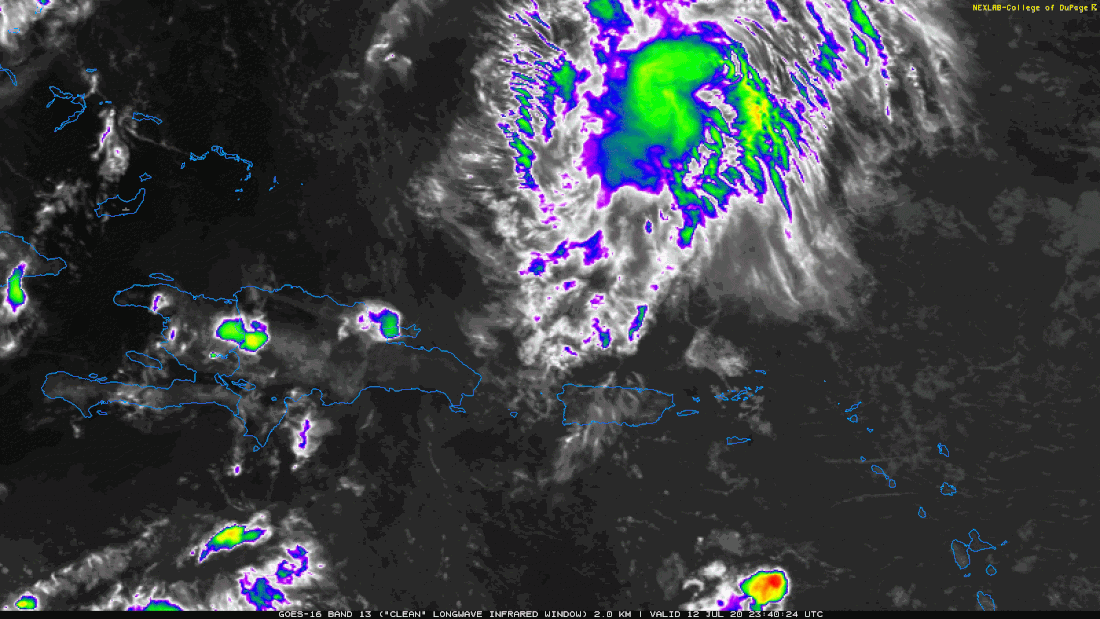 Figure 1. Puerto Rico Blob losing convection. Cristina located in the Eastern Pacific has been downgraded to a Depression. 98E is new, as is 99W. 99W is the only one showing much convection. Much of which is over the Northern Philippines.  Figure 2. 99W Look Ahead: July, August, September North American Anomalies A hot drought looks to be setting in across much of the western United States. Some cooler than normal temperatures should persist but are expected to move more to the Midwest. Rain gets contained more to the eastern half with the South expecting plentiful rain this summer. 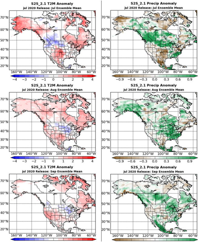 Figure 3. NASA's GMAO S2S_2.1 Seasonal model. The left side is the forecast Temperature Anomalies, the right is the forecast precipitation anomalies for North America. This covers the months of July (top), August & September (bottom).
...RECONNAISSANCE AIRCRAFT FINDS TROPICAL STORM FAY HAS FORMED JUST OFF THE COAST OF NORTH CAROLINA... ...EXPECTED TO BRING HEAVY RAINFALL AND GUSTY WINDS TO PORTIONS OF THE MID-ATLANTIC COAST AND SOUTHERN NEW ENGLAND...NHC
Fay is located about 195 MI...S OF OCEAN CITY MARYLAND MAXIMUM SUSTAINED WINDS...45 MPH... PRESENT MOVEMENT...N OR 360 DEGREES AT 7 MPH... CENTRAL PRESSURE...1005 MB...29.68 INCHES. Fay is forecast to be near the mid-Atlantic coast on Friday, and move inland over the northeast United States on Saturday. Some strengthening is expected before landfall. So far storm surge doesn't look to be much of an issues other than being a little above Astrological Tide in some places along the Mid-Atlantic coast. Overall the worst impact is expected during low tide. Embedding the current forecast cone with warnings.
 Embedded Wundercams.. gallen11CAM12 Ocean City, NJ SoMASCAM1 Shinnecock Hills, NY MoneyIslandCAM1 Branford, CT World Tropics
98L came together in the Gulf of Mexico before coming onshore yesterday and traipsing through the Southeast overnight and in to today. It hasn't caused much for damage yet. SPC has nothing in the south for yesterday or today. Wyoming had a tornado yesterday as well as other wind reports in that region. Pennsylvania and New Jersey also saw wind and hail.
Stu Ostro caught 98L making a rainbow over GA.
Embedding the three day precipitation forecast and WU Radar, to keep tabs of the most current.
 Quantitative Precipitation Forecasts  Wunderground Nexrad Radar
Updated Saturday Morning 07/04/2020
Persistent convention has developed into a small area of low pressure located between Florida and Bermuda. National Hurricane Center is giving it a 60% chance of developing and has dubbed it 97L. It is expected to continue East-Northeast. Late Sunday conditions for development in to a tropical system are expected to degrade. Those with interests in Bermuda should monitor this storm. Friday afternoon Florida storms have come together in a blob that is now following behind 97L. 2020 Mayflies Coming Out Thick
After 9pm Thursday July 2nd, this swarm of freshly hatched mayflies was spotted in Burlington, Iowa. Worst affected looks to be areas south of the Twin Cities metro. In Hastings most outdoor lights such as street and river front lights will be turned off throughthe weekend.
Swarms were large enough to be spotted in several areas along the Mississippi River using radar.
|
Current Tropics and Weather News..
Archives
January 2022
|

 RSS Feed
