|
Welcome to Skyepony's Weather Blog.
|


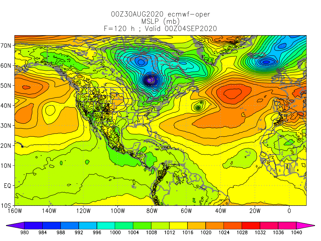
99L and 90L 99L was declared first and has just entered the Eastern Caribbean. It is developing from a wave that had been building convection in the Main Development Region. CMC was the only model developing this much at first and took it into Central America and the Eastern Pacific where the CMC and other models develop it into a storm. It looks more gamely than models predict so the forecast for this is pretty uncertain. Another area of interest is over Northeast Florida is now moved offshore and has been designated as 90L. That is expected to become a storm off North Carolina the afternoon of September1st. The ECMWF has this storm run into and take a smaller satellite low around it and absorb it. Either way this moves East-Northeast across the Northern Atlantic, the larger effect plays out on the Atlantic High as a third area of interest that is coming off Africa develops. These two storms move across the Atlantic in opposite directions possibly pumping the ridge from the bottom and top back toward the Western Atlantic and United States, preventing the southern storm from re-curving out to sea. Global Tropics
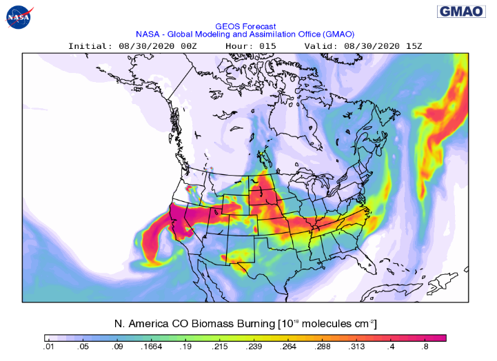
September Look Ahead September 2020 overall is expected to be a hot month for the Earth with a few cool pockets left around the Antarctic and Eastern Pacific as La Nina intensifies. The expected well above average heat in the Arctic for this coming Fall should really begin to set in. As a sign to the interesting times ahead Siberia just had a new hydrolaccoliths open up, #17 and it's by far largest one yet, since they first appeared in 2014. These are giant holes or funnels that open up from permafrost melting and methane gas accumulating underground. The gas gathers in a large bubble, deforming the earth into a mound called a pingos until it explodes/gives way to a giant hrydrolaccoliths. This one was much larger and had new findings that haven't been announced yet as they study the data and plan to release scientific papers. Major concern is being noted that from satellite and helicopter inspections many pingos have been spotted, some literally holding up fuel pipelines. This is the last month above average rain is expected over the Mississippi Valley and Mid-west for a while. Florida and the Mid-Atlantic coastal regions can expect above average rainfall as well with the continued hyper active Hurricane season in process. Central America can expect more devastating flooding as storms generally gravitate more west with La Nina setting in. Globally the southern area of Southeast Asia and the wave train across Africa are also expected to take some of the heavier flooding. India is still expected to have above average rain but it is a little less than August. The fires out west have added smoke to watch this coming month as well. In the coming week the smoke plume drug across the United States by Laura should work it's way back to thicker smoke along the West Coast. Best of September to everyone. Arctic Sea Ice is close to a new minimum but probably won't break the record. North America and the Caribbean have taken above average storm damage so far this year and will likely take more, while corona is still wrecking havoc on lives and populations. Look out for each other, stay well and prepared. This too shall pass..
Comments
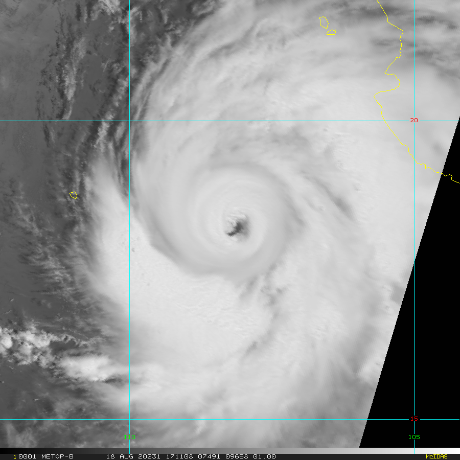
 Figure 1: Near Real Time IR of Laura from College of Dupage, Nexlab.  Figure 2. Real time National Hurricane Center Key Messages. One of the more deadly expected effects from Laura to the Northern Gulf Coast is high storm surge. Evacuation orders in flood prone areas should be followed.  Figure 3. NHC Experimental Peak Surge Graphic. Figure 3. NHC Experimental Peak Surge Graphic. Figure 4. Wunderground Nexrad Radar. Refresh page or revisit to see the latest of these first four images.
Figure 5. A growing slide show of saved Laura images.
Wundercams
codyneilCAM1 Crystal Beach, TX
ChesterCamCAM3 Seabrook, TX jlp09550CAM1 Abbeville, LA K4QALCAM1 Slidell, LA GHerosCAM1 New Orleans, LA Refresh for latest web views. If a cam isn't working, it's most likely lost power. Live webcam in Lake Charles Live Galveston Seawall Live Storm Chasing Laura Left Damage in Cuba
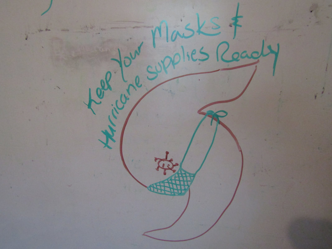
Cuba had a covid complicated storm as normal evacuation procedures were hampered by keeping people safe from the pandemic. The capital city is still on lock down while the rest of the country was just returning to the new normal. Evacuation went as usual with the addition of masks, hand sanitizer and less shelter capacity in an attempt to shelter the masses in a less huddled manor.
Heavy rain and wind was felt across all of Cuba, some trees and power-lines fell. The shoreline both north and south had damage from flooding and waves. Much of the eastern Cuban town of Baracoa sustained damage to buildings and homes along the seafront. Two fires occurred from Laura, one at a school, the other at a poultry farm. The video below captures some of this and a partial building collapse where people were sheltering. Above is a growing Marco and Laura slide show. ...HURRICANE HUNTERS FIND MARCO HAS WEAKENED... ...HURRICANE AND STORM SURGE WARNINGS REMAIN IN EFFECT FOR PORTIONS OF THE NORTHERN GULF COAST... Max wind speeds are 70mph. Moving NNW at 12mph. It is forecast to slow down and move west into Louisiana. There is a lot of divergence and disagreeing between the models for both storms. Models have handled Marco a little better. HWRF is the model with least average error so far for Marco. Some of the better preforming models over 5 days on Laura are the UKMET & LGEM. Surge maybe worse for Laura. Sabine Pass, TX is forecast for 8 1/2ft storm surge. Wouldn't be surprised to see Marco land a little east of forecast and Laura to head a little south. Flooding in Hispaniola from Laura has been devastating. At least 9 died in Haiti and 3 in the Dominican Republic.
Laura struggles on with structure but maintains some convection. Portions of the Leeward Islands can expect Tropical Storm conditions Cone has shifted south a bit.
A look at model performance on Laura has UKMET on top for the three day average. These are top three that have made a storm forecast for Laura that have been running daily for at least three days. Model error in nm: model 1 day 2day 3 day UKMET 79.1 125 110.6 CEMI 74.9 69.9 136.9 TABS 90 115.9 115.8 OFCL now has one 24hr forecast with an error of 67.2nm. It and the top two models also beat out the ECMWF global model which had 83.2nm of error. Lot of uncertainty in play... 13L Laura
 14L Marco
 14L at times has showed a quick gather of structure but struggles with land, dry air and general lack of convection. It has slowed it's forward speed to 12kts and is maintaining a wind speed of 30kts with gusts to 40kts..

This is a fairly dynamic and hard to predict storm outcome. Either could grow stronger, draw in and devour the other. Marco has structure, Laura has convection. There has been some model runs that make this into one giant circulation. They are both weak and it is more likely they slosh into the gulf one after the other, maybe do a quick dance. It is the current solution, with 14L being favored as a little stronger.

Images note: All the images up to this point including the Key Messages but excluding the Tropical Depression 14 slide show, updates when the page is refreshed.
Global Tropics
Wunderground Community on the Move
The comments on Wunderground are gone.. We are flying the coop to YCC. The commenting section there is different but we are figuring it out. There will be an upgrade there sometime this Fall. Here is the link to Eye on the Storm section, just select the latest blog. Give it a try. Many are still posting on the last blog comment section for WU on the disqus mirror site. We don't know how long that might last.
 Figure 1. Two day outlook from NHC. Refresh page for latest.
NHC has three areas of interest in the Atlantic. 97L now Tropical Depression 14, is in the Caribbean and is expected to move toward the Yucatan Peninsula and then the Gulf Coast. The storm in the Central Atlantic is Tropical Depression 13L. Models are currently gunning for South Florida the most but there is a bit of spread and they are still shifting around. Third is a new wave stepping off Africa.
Tropical Depression 13L
Figure 2. A slide show of 13L. This is a work in progress with new pics and gifs added regularly.

Figure 3. NHC Key Messages for Tropical Storm 13.
97L- Now Tropical Depression 14
Figure 3. A slide show of 97L. This is a work in progress with new pics and gifs added regularly.
 Figure 4. NHC Key Messages for Tropical Storm 13. Global Tropics Continue to be Active But Weak
Tropics are fairly dynamic at the moment with mostly weaker storms, some short lived. Ex-Josephine is north of Puerto Rico, heading generally north. Shear decapitated the upper convection yesterday. A strong outflow boundary from the collapsing convection disrupted the circulation to where it became an open wave. Southeast of there, approaching the Windward Islands is 97L. Another area of interest is located just off Africa. These two storms have some model support to pull together while in the Caribbean and eventually end up in the Gulf of Mexico.
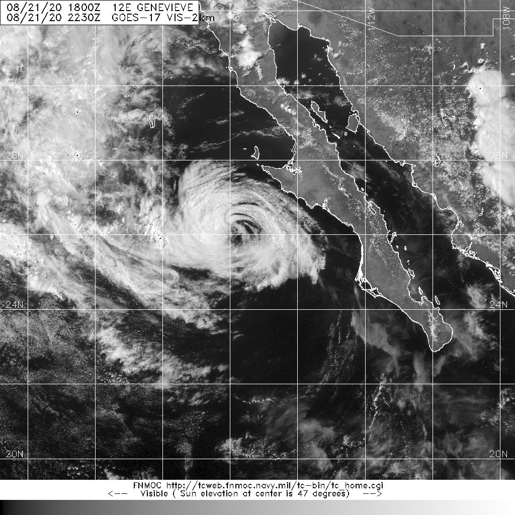
Even more lively in the Eastern Pacific is 12E Geneviev. This is the first storm in sometime that is expected to reach at least hurricane strength. Rapid strengthening is expected thru Tuesday. Wouldn't surprise to see this become a major. The models have changed around where this storm is headed enough. It should generally parallel the coast heading north-northwest. How far off shore is yet to be seen. 
Refresh page to see the latest on the two graphics above.
Also in the Eastern Pacific is 11E Fausto which is expected to become a remnant low later today. 10E is still churning out there as 90C is also persisting south of Hawaii. In the Western Pacific there is a volley of invests. Though we lost 98W, 97W persists, 99W was new yesterday and 90W over last night. A Look Ahead
NASA's GMAO site was down for days, which caused this delay in the monthly look ahead.
Kyle- Earliest K StormKyle formed over the Western Atlantic today, the earliest K-storm to form in the Atlantic Ocean records. It has wind speeds of 40kts and is expected to move to the East Northeast further out to sea. It is currently moving at 17mph and has a minimum pressure of 1008mb. The water temperatures are helping create convection but shear is displacing the upper portion toward the east, exposing the lower level circulation. 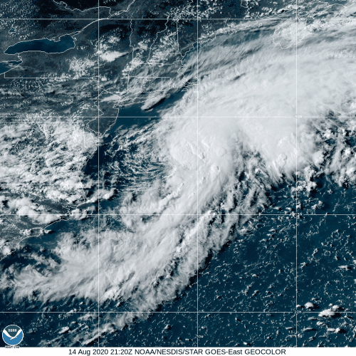 Josephine Heads into Ever Worsening Sheer Josephine fell apart a bit and then reformed a little farther north today from what recon found. It has winds of 40 mph, pressure of 1004mb. Josephine is traveling West Northwest at 16mph. Tonight may be it's last shot at strengthening before conditions grow more unfavorable. NHC expects it to move north thru a weakness in the ridge and weaken to a tropical remnant within four days. 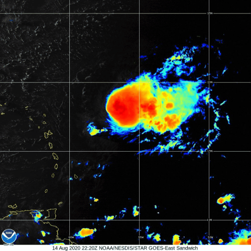 Other Storms MJO is growing stronger in the East Pacific and invests are popping. 10E has a beautiful structure but little going on in the upper levels. 93E is bringing rain to the tip of Baja. New today is 94E and 95E. 94E looks gamely. 97W is so large it's having trouble gathering. 97B is pouring on Bangladesh, adding to the extreme flood there. Releasing GMO Mosquitoes in the Florida Keys During a Pandemic
Atlantic Tropics
96L has Formed off North Carolina
This may become a storm and move north of Bermuda and east across the Atlantic. It started farther south yesterday, west of ex-94L as it dissipated. Central Atlantic Coast could see some surge near a foot above highest astrological tide and rain as it gathers before exiting across the Atlantic.  Figure 1. Central Atlantic Coast on Goes-16 Sandwich. This shows the real time image when the page is refreshed. Josephine- Leeward Islands should monitor this storm. It is forecast to increase to 60kts and stay out at sea and then diminish in unfavorable sheer.
Slide show of Josephine from newest to oldest. Check back for more as it traverses the Atlantic.
 Josephine cone and warnings. This graphic self updates when refreshed. Eastern Pacific
Elida Caused extreme flooding damage in Comila, Mexico before it strengthened into a Category 2 storm. It has wound down and dissipated. Rain from Elida remains are reaching California.
Tropical Storm Ten has formed. It is forecast to head west for at least 5 days while remaining weak with a peak of 40kts.
In Other Tropics.. 97W & 98W have formed in the West Pacific. 97B is in the Indian Ocean. Disaster White Board Update
Watching a few swirls in the Atlantic. One is off Florida. It is ex-94L that has been wandering around the Western Atlantic north and east of the Bahamas. It recently moved Southwest, more toward Florida. Ex-94L has had good structure but has been mostly devoid of convection. At times like yesterday (08/08/2020) convection started firing from the surface but it failed to persist long before reverting back to naked state.
Figure 1. Ex94L Slideshow
Looking toward the east at the Main Development Region the Tropical Wave just off Africa has had some inconsistent model support at becoming something. National Hurricane Center has designated this as 95L.
Figure 2. A slide show of 95L. More pics to come.
The MJO is currently concentrated over the Western Pacific with a weaker area of conducive lift in the Atlantic. It is expected to move through the Easterm Pacific where models have the most hurricane action next week. Up to three storms may form off Mexico and move off in a parade formation toward the West-Northwest. First up is the newly christened Elida, a poorly organized storm paralleling the coast of Mexico that should move out to sea. The West Pacific is most active at the moment with 05W Jangmi, 06W & 07W. Jangmi is not expected to grow much stronger than a 40kt storm and is forecast to move between South Korea and Japan.
|
Current Tropics and Weather News..
Archives
January 2022
|


 RSS Feed
