|
Welcome to Skyepony's Weather Blog.
|


This all inspired a new Climate Connections Critter.. Supercell 
Comments
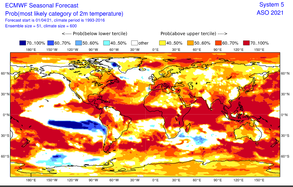
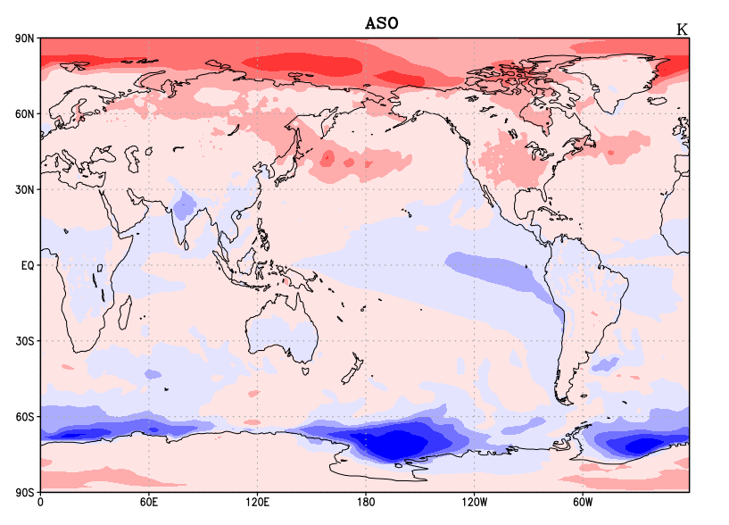
Looking ahead from April in the height of the Spring ENSO barrier models are still taking drastically different outlooks for the coming summer. Looking at my two favorite models for this, ECMWF and NASA GMAO, there is a fair spread on what ENSO might do. ECMWF is not so clear on the graph below. The plume can be viewed here. It is largely undecided with the majority being a warm neutral region 3.4. 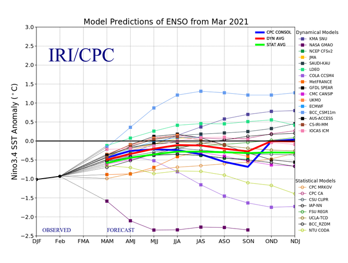 There is a lot of similarities in the summer forecast though. The cold water coming up from the Southern Hemisphere and sweeping out west across the Pacific Ocean is present in both. ECMWF just has it moving west farther south, not in the area ENSO is gauged. Both models show a hot year. ECMWF has overall hotter with less cool water in the Antarctic region. Below is a comparison of Global Temperatures at 2meters for Aug Sept Oct, ECMWF on the left and NASA's GMAO on the right. In both hot is red, cool is blue.
Overall the two least realistic looking things for these models are.. GMAO really cools much of the Arctic down to near normal some months over the summer. In past runs this cool down should have started two months ago and keeps being warmer in the near term than forecast. Expecting the Arctic heat anomaly to not be as hot this summer as it has been through the Northern Hemisphere colder seasons as this is how Climate Change has been rolling, but probably not as cool as GMAO is forecasting. The extreme La Nina forecast is a bit of an outlier too. Though still wouldn't be surprised to see La Nina re-strengthen some as we go into summer. As for ECMWF the cold plume forming so far south in the Pacific Ocean looks unrealistic. The Antarctic maybe forecast a little warm as well.
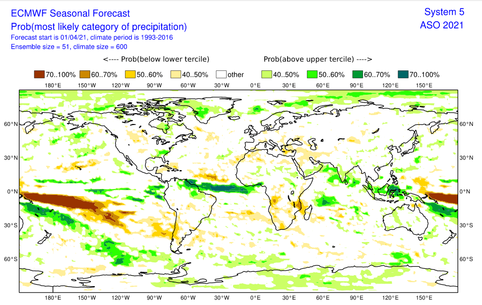
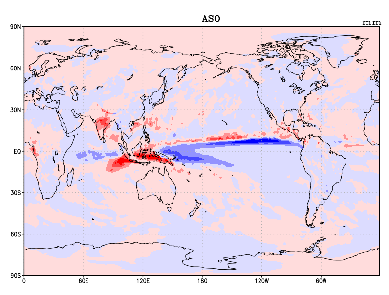
Above is a comparison of global precipitation anomalies for Aug Sept and Oct. Left is ECMWF, right is NASA's GMAO (blue is less rain than normal, red is more). Both generally show more rain expected around the poles with large areas of extreme dry in the Pacific and a rainier than normal Atlantic Ocean. Overall the coming months look hot and dry for much of the land portions of the planet. If the trend of late holds, when it rains chances are it may downpour very heavy precipitation and possibly frozen, in the form of hail.
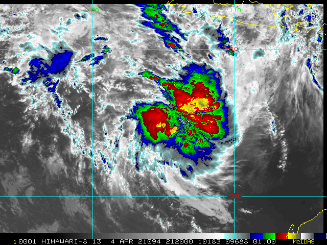
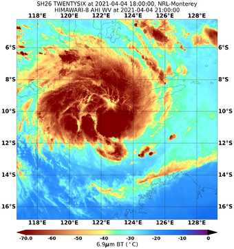
90S & 99S have become 27S & 26S respectively. 27S is on the left above & sits west of 26S off of Australia. 27S currently has winds of 35kts. It is forecast to strengthen to 65kts in 96hrs before weakening. 26S is more north of Northeast Australia. Currently it has winds of 45kts and is forecast to strengthen to 100kts in 96hrs and then begin to weaken. This storm may affect some islands in the next few days. Rain on the Farm It finally rained last Friday. Nearly 2 inches of precipitation fell, all at once. Later that night we had some long but healthy looking oak limbs cracked as the wind picked up. One fell, barely missing the bees. This hive moved in last fall, settling in a box that had been placed teetering on the precarious block pile. Had they not been moved they would have been hit by the smaller limb. A second larger limb is behind it, cracked and still hanging from the tree. It's time they got moved again and given an even better block base. 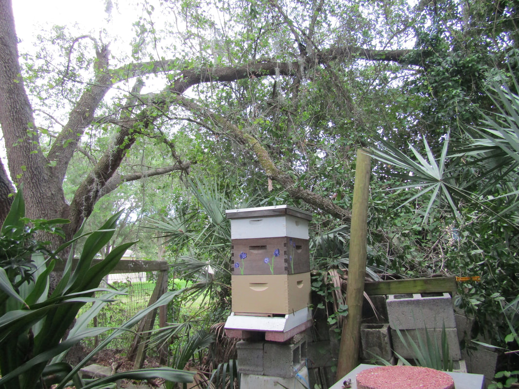 Had some dead fall to pick up out by the ditch as well. Yellow flowers were everywhere. Got to looking closer. It was peanut hay. Had sown some seeds in a sunny spot along the ditch hoping to get it established somewhere the herd couldn't eat it all. It is a low ground cover that doesn't need mowed, released to the public by UF Agricultural Extension. The plant needs little water and care so seemed like the ideal placement. It certainly has flourished with neglect and has already produced bean like seed pods near ready to harvest. Collected a few of the flowers for an Easter arrangement. 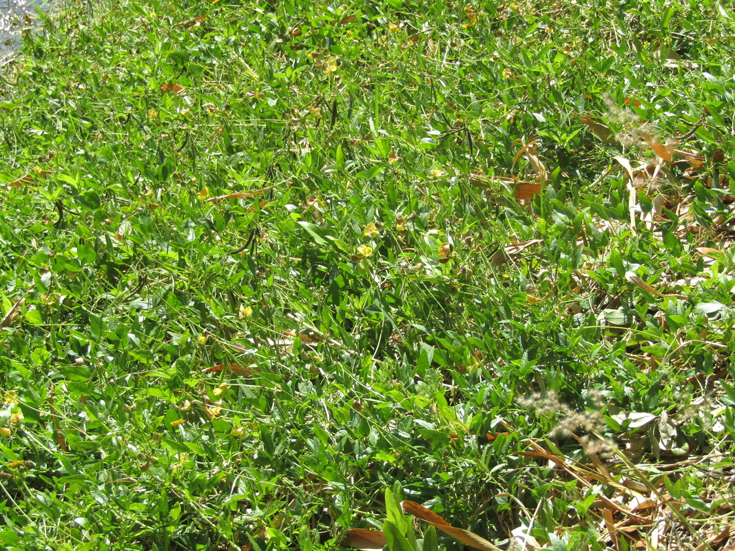 Perennial Peanut Hay is not just a favorite of the grazing livestock, the bees are enjoying this plant now that it is established and not just arriving as bales of hay. 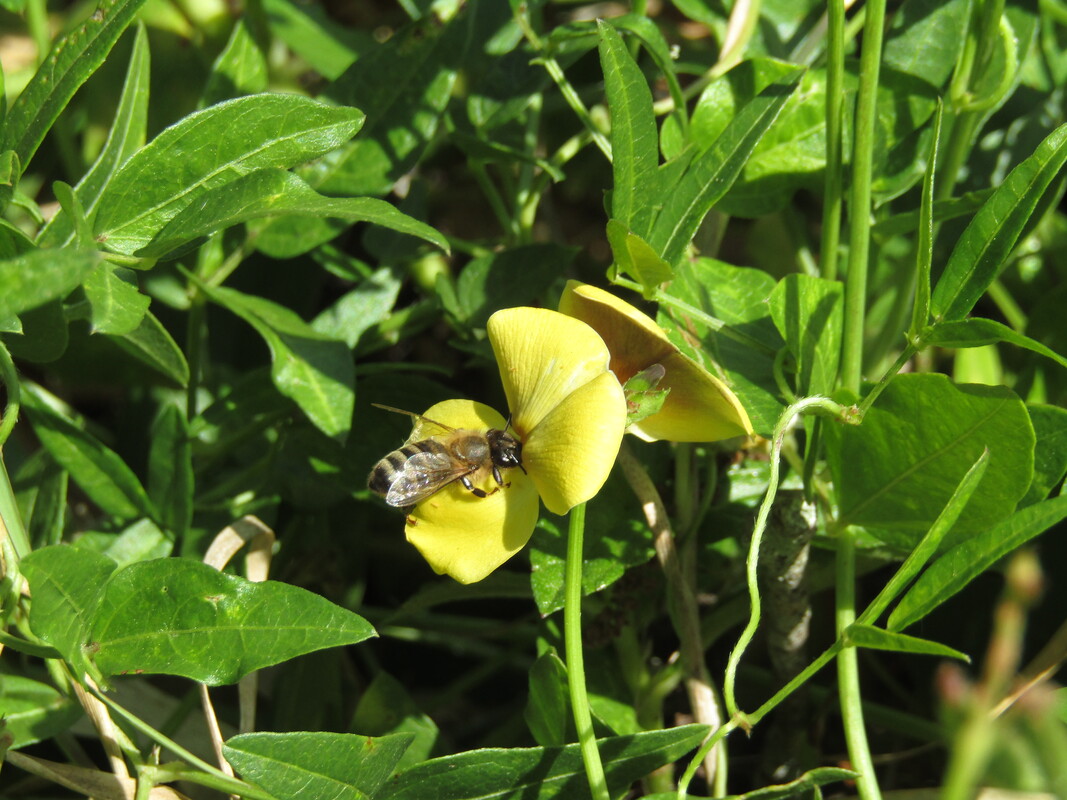 It's that time of year to attempt to peer past the spring barrier, to glimpse at what ENSO may hold and some possible general weather patterns for the rest of the year. As of March 29th La Nina was present with Region 3.4 at -0.6C. NOAA currently gives a transition this spring to neutral ENSO conditions, a 60% change of developing. In recent weeks the negative temperature anomalies in the Pacific Ocean have warmed some and then cooled again slightly. Generally looking at potential and existing Kelvin Waves, this sort of equatorial wave could change the winds and let the warm water in the West Pacific slosh back to the east. This time of year cyclones from north of Australia to Africa, especially when two or more start pairing up and straddling the equator can cause a Kelvin Wave to get started. 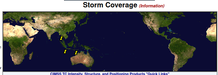 Figure 1 shows that is what the tropics are currently attempting, but the storms have been weak. The I's are for invest, areas of interest and have yet to organize. 90B is in the Northern Hemisphere. 90S is below it in the Southern Hemisphere, 99S is to the east, just offshore of Northeast Australia. All three storms have struggled for about 2 1/2days. These storms were proceeded by another cluster of storm a little farther west that never developed. No Tropical Cyclones have managed to form and pull it together enough to be named in weeks. 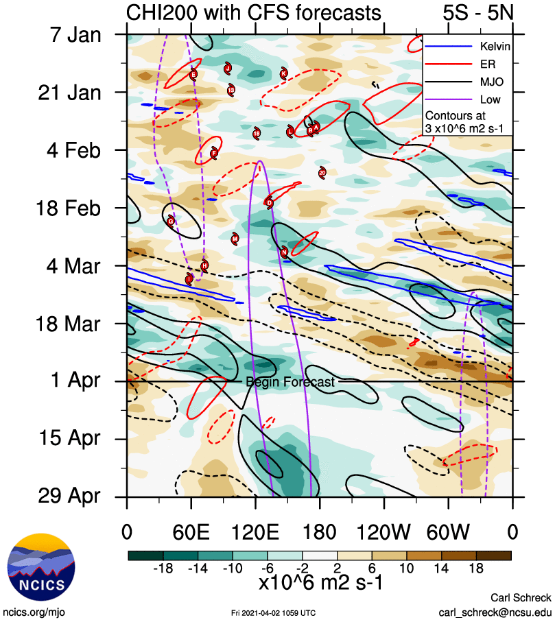 Figure 2. Potential Velocity thru time (vertical axis by date), across the Earth (horizontal axis by longitude). Storms best form when Potential Voracity is positive (brown). Kelvin Waves (blue), Equatorial Rossby Waves (ER marked in red), Madden–Julian Oscillation (MJO in black) and general areas of Low Pressure (purple) all help develop storms. Looking at the CFS forecast, strong storms don't look as likely to form in April, particularly in the area needed to kick up Kelvin waves. 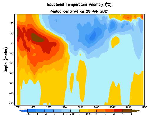 Image 3 is the Equatorial Temperature Anomaly of the Pacific Ocean by depth. The top represents the surface where as the bottom is 450m deep in the ocean. This shows some sloshing taking place and heat moving below the surface weakening the current La Nina state. The heat started with quite high temperature anomalies. Those too were weakened. This is probably where some of the forecasts for Modoki La Nina summer are coming from. If that heat around 120W comes to the surface, a cool pool will likely be left out in the Central Region 3.4 while the eastern half warms. 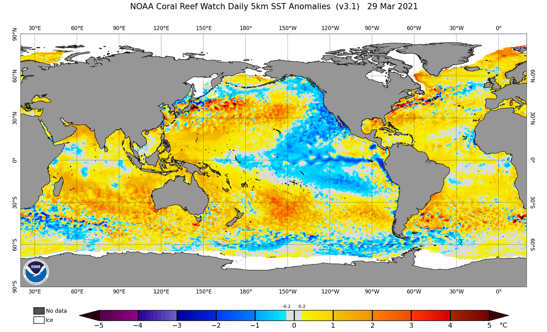 Image 4 shows the source of the La Nina, the cold water coming up along South America, being swept out along the equator from there forming well established Tropical Instability Waves . It was cut off a few weeks ago. Region 1.2 (the farthest East Pacific) had an abrupt warming to 0.8C and then quickly dropped to -0.8C over the month of March. If this current wind current flow continues La Nina would continue and most likely strengthen. If it stops this could all warm fairly fast. 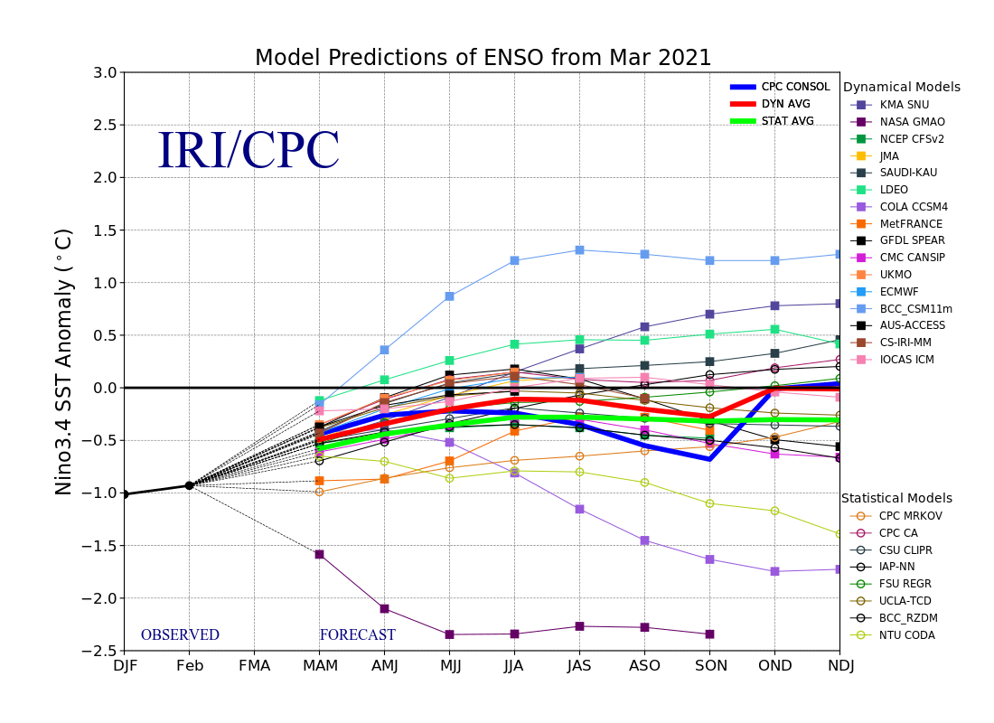 Image 5 reflects the various outcomes with a wide spread in the models. Statistical models lean a little cooler earlier on. Both Dynamical and statistical models averages point to a cool neutral by summer carrying on into fall. 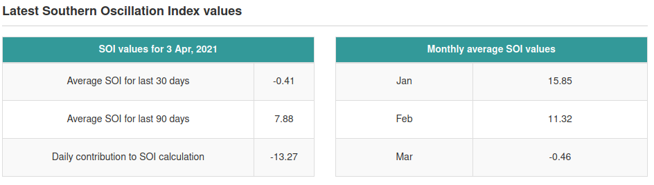 Image 6... SOI reflects the current cluster of invests, current MJO and some stronger storms near a month ago. It has certainly moved away from La Nina. As of 5 days ago the Australian Government Bureau of Meteorology declared La Nina done and conditions neutral based on SOI and the models. NOAA waits til the atmospheric effects take hold on the ocean Sea Surface Temperature in Region 3.4 and then uses the 3 month average there to determine the current ENSO situation.
Overall this year seems to have a thicker spring barrier than some. Neutral looks most likely of the three looking at models and SOI, but extreme temperatures on both ends could easily end up in Region 3.4 over the summer depending on how the Pacific Ocean sloshes and the winds that determine that. Though neither can be ruled out, of the two La Nina looks more likely. If we continue to see a dearth in storms, La Nina especially by the three month ONI standards, may very well remain. |
Current Tropics and Weather News..
Archives
January 2022
|
 RSS Feed
