Skyepony Weather
  • Skyepony Weather
  • ECFL Weather
  • Wildfire Links and Graphics
  • Skyepony Weather
  • ECFL Weather
  • Wildfire Links and Graphics
Welcome to Skyepony's Weather Blog.
A site to check out storms. A place to check for invests MIT storm forecast & intensity models
Locations of Site Visitors

Maria and Lee Leave for the UK, What's Next?

9/27/2017

Comments

 
Maria is around her closest expected proximity to the United States.  The tide gauges have been up a little higher than Highest Astrological Tide at times.  She may linger another day but then should move away, taking Lee with her.  These two may quickly whisk off to the United Kingdom, look out for them there.

So what is next?  With good atmospheric lift happening and more MJO coming the models seem to be having a hard time agreeing on where.  The wave south of Cuba appears most vigorous.  Look to the comment section here for model reviews.
SaltRun's Wundercam in St Augustine, Florida

Cayman Islands Port Authority Webcams

Comments

Irma in Melbourne/Watching Atlantic

9/15/2017

Comments

 
Irmageddon came to be as supplies ran short or out.  After days of preparing we were ready to ride out the storm.  I stayed on the farm to tend the animals.  Looked like a long storm coming.  The wind picked up well before the real winds and tornadoes followed.  Here is a video where I captured a vorticity traipsing through my backyard.  A few minutes after this electricity in the neighborhood went out for 3 days.  In the early evening, waited for a break in the higher gusts to check on the herd.  The pony stalls were beginning to flood.  So hung haynets in there.  The cows wanted no part of the woods or the high shed there.  They were standing in 4inches of water under the treefort, left hay in the rack there.  Here is some haying cows in the storm..  It continued to pour rain.  It seemed to be unable to flow as well as the winds had it pinned from the canal.  The barn feedroom came within 3 inches of flooding.  Knew had neighbors flooding. 

Nearing midnight the storm was closer, winds higher and cows had moved to the west side of the barn on a high spot.  They were still standing in water.  It was not much longer and Penny-Moo gave out a bellow of get me out of here.  So next break in the winds, opened the gate to let the herd out in the yard.  The cows had no place to lay down in a sheltered area and the ponies were in water or under trees, it was the best option.  The water was so deep at the gate the calf nearly had to swim out as it was.  Once up on the house pad and back porch they settled into some sheltered spots and hay.  As the winds were about to switch and increase Elzari, our mare insisted the boys of the herd come out of the way back and take proper shelter as well.  Sometime later they sheltered in the gardens, ate all the collards, kale and decimated the okra.  Skye the actual Pony spent some of it under the front porch, between the vehicles.  He doesn't care for getting wet. 

After the storm passed, the backside was pretty dry and blew the highest water up and out the drainage canal.  By morning the sun came out.  The herd wasn't ready to really leave the sheltered, mostly debris free area of high ground.  The wind was still up.  They just wanted more hay..
Picture
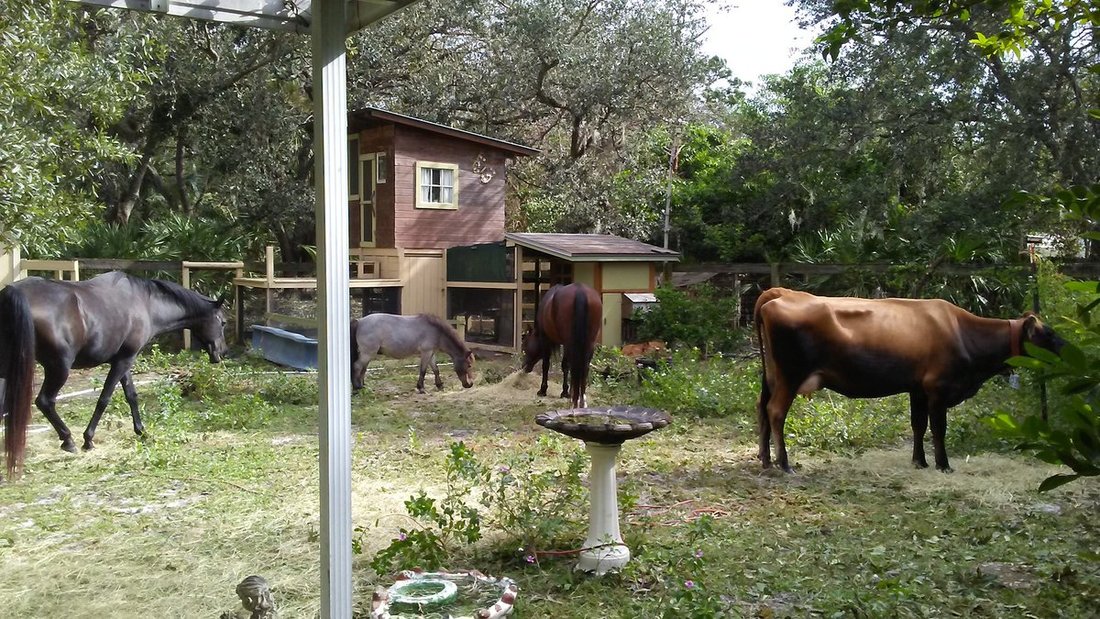
For storm damage we were pretty lucky.  The roof over the feedroom needs repaired or replaced again.  Lost the fog light cover for my vehicle and my refrigerator didn't comeback after the power outage.  The pasture was hit by a tornado.  The beautiful ear trees took a harsh beating and loss of huge limbs.  We got the wood fence stood up the next day.  All the building around there were missing shingles.  The gas staions nearby all had severe canopy damage.  This one is at the corner of Lake Washington Rd and Wickham Rd.
Picture
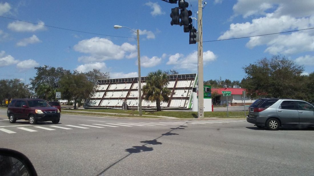
Heard stories of where shutters were ripped off houses.  One guy in Indialantic had his sheds full of lawn equipment for his business take off to the sky to never be seen again.  They think it maybe in the Indian River.  Looping through town on the hunt for a new fridge we snapped these pics.
Looking at storm reports for East Central Florida.  Brevard County had the highest reported winds of 93mph in Playalinda Beach.  85mph was reported in Cape Canaveral.  Cocoa Beach had 83mph winds.  Haulover canal had 81mph gust.  Camp Holly Fish Camp near me but farther west had winds of 78mph.   Orlando International Airport had winds as high as 78mph.  Leesburg clocked 69mph, Sandford 75mph.  The worst flooding issues were both along the coast and the St John's River.  Water rescues were reported in both areas.  Volusia, especially Daytona Beach east of US 1 flooded badly as did parts of Indialantic and Fellsmere.  Orange county had water rescues mostly after the storm as the St Johns River came into houses.

We are waiting to take all the shutters off the house and barn.  Jose is still out there.  Models have been trending west on him.  Probably be some effects at least in the Northeast.  Some runs have had 14L hit the east coast of Florida hard.  Now 96L  which just became PTC15L is looking like a possible threat..  Hard forecast with those two storms so near each other..
Comments

Watching Irma

9/4/2017

Comments

 
2o1oo's Wundercam

St Barth Webcam

Ride along with WP-3D Orion #NOAA42 for the first flight through #HurricaneIrma. Flights continue today. Credit LT Rob Mitchell/NOAA pic.twitter.com/7sjigdNiv7

— NOAAHurricaneHunters (@NOAA_HurrHunter) September 4, 2017
Comments
    Current Tropics and Weather News..
    Donate to Skyepony Thank you for visiting and supporting!
    paypal.me/Skyepony

    Archives

    November 2020
    October 2020
    September 2020
    August 2020
    July 2020
    June 2020
    May 2020
    January 2020
    December 2019
    November 2019
    October 2019
    September 2019
    August 2019
    July 2019
    June 2019
    May 2019
    April 2019
    March 2019
    January 2019
    December 2018
    October 2018
    September 2018
    August 2018
    July 2018
    June 2018
    May 2018
    April 2018
    March 2018
    February 2018
    January 2018
    December 2017
    November 2017
    October 2017
    September 2017
    August 2017
    July 2017
    June 2017
    May 2017
    April 2017
    March 2017

    Categories

    All
    03L
    07L
    08L
    14L
    2017 Insurance Costs
    2017 Satellite Images
    2018 Hurricane Season Forecast
    2018 Weather Forecast
    2019 Harvest
    2019 Hurricane Season
    2019 Hurricane Season Forecast
    28W
    90L
    91L
    91W
    92L
    93E
    93L
    94L
    95L
    96L
    97W
    98L
    99L
    Alalog Weather Years
    Atlantic Swirl Watching
    Atlantic Tropics
    Atmospheric Leak
    Barry
    Beryl
    Big Hail
    Big Waves
    Blob Watching
    BombCyclone
    Bomb Cyclone 2019
    Bulbul
    Chris
    Climate Change
    Cocoa Beach Pier
    Cold Mountain
    Colorado Flooding
    Concert Weather Safety
    COrn
    Cranberries
    Cummins Falls Flood
    Cyclone Calvinia
    Cyclone Cook
    Cyclone Ernie
    Cyclone Iris
    Cyclone Jelawat
    Cyclone Nora
    Disaster White Board
    DIY Solar Generator
    Don
    Dorian
    Dorian Stories
    Earthquake France
    Earthquake Map
    Earthquakes
    ECFL Eclipse 2017
    #El Nino Coming
    Emily
    ENSO
    Eugene
    Falcon 9 Fail
    Fall & Winter 2019/2020
    Fay
    Fengshen
    Fernanda
    Ferry Capsize
    Flooding
    Flooding Greece
    Flooding Puerto Rico 10/16/17
    Florence
    Florida Fire Weather
    Florida Thanksgiving Weather
    Florida Tropics
    Fort Fowl
    France Flooding
    Franklin
    Freezing T-shirt
    Fuego
    Genevieve
    Gert Surfing
    Gita
    Glacial Flood
    Glacier Outburst
    Gordon
    GPM Philippe
    Greyson
    Ground Opens In Mexico
    Hail
    Haishen
    Haitang
    Harvey
    Harvey Unemployment
    Harvey Vs Diesel Trucks
    Hato
    Heat Wave
    Hoi An Flooding
    Homemade Rocket
    Humberto
    Hurricane
    Hurricane Bud
    Hurricane Dora
    Hurricane Harvey Coloring Book
    India Landslide
    Irma
    Irma Damage
    Irma In Melbourne
    Jamaica Flood
    Jellyfish
    Jose
    Josephine
    JPSS-1
    July 2018
    July 2019 Weather
    July Weather
    June Volcanoes
    Kenneth
    Kilauea's Gemstones
    Kilauea SO2 Plume
    King Tides
    Krosa
    Labor Day Storm 2018
    Lake Okeechobee
    Lan
    Laura
    Lava Song
    Lesotho Hail & Flood
    Levee Database
    Lidia
    Local Flooding
    Loon Balloon
    Marco
    Maria Fentanyl Shortage
    Matress Mack
    Mavericks
    Mayon Volcano
    Maysak
    Medicane
    Mercury Transit
    Mike Hughes
    Mississippi River Flooding
    Montacello Mudslides
    Montecito Mudslide
    Montreal Ottawa Flooding
    Nana
    Nanmadol
    Nepal Flooding
    Nesat
    New Jersey Flooding
    Noctilucent Clouds
    Noreaster
    Nor'easter Watch
    Noru
    Okeechobee Resevior
    Omar
    Oysters
    Pakistan Hail
    Pecans
    Pennsylvania Flooding
    Peru Flooding
    Phallic Sky Writting
    Philippe
    Post-Irma Brevard Flooding
    PTC16
    PTC9
    Puerto Rico Internet
    Radioactive Cloud Over Europe
    Rain
    Raymond
    Red Tide
    Remedy Tree
    River Gauges
    Rockledge Funnel Cloud
    Sally
    Seasonal Forecast
    Sebastien
    September Weather 2020
    Seven Day Rain Forecast
    Severe Weather
    Skyepony Weather
    Southeast Rain
    South Garden
    Spring
    SST Forecast
    Storm Model Error A-F 2020
    Surf Hawaii
    Surfing
    Suwanne River Record Low
    Swirl Watch
    Swirl Watching
    Talas
    Tembin
    Texas Rain
    Thomas Fire
    Today's Rain Forecast
    Tornadoes
    Tropical Depression 3
    Tropical Storm Blake
    Tropical Storm Don
    Tropics
    Tucker Fire
    TX Hail
    Typhoon Hagibis
    UK Flooding
    Upgrade
    US Radar
    Venice Flooding
    Volcan De Fuego
    Volcano Map
    Weather
    Western North Carolina Tornadoes
    Wildfire
    Wildfires
    Wind Chaos
    Windmageddon
    Wind Vs Bounce House
    Wine
    Winter Wheat
    World Tropics
    YCC Move
    Zeta

    RSS Feed

Powered by Create your own unique website with customizable templates.