|
Welcome to Skyepony's Weather Blog.
|


|
Current Eta Graphics
Eta Slide Show
Eta storm: a landslide buries a hundred people in Guatemala
Noticias Telemundo-
Official video of Noticias Telemundo. The landslide, caused by the intense rains in Eta, destroyed at least 25 houses with dozens of people inside in a village in Alta Verapaz. The catastrophic rains have submerged entire communities under water in Nicaragua, Honduras, Guatemala and El Salvador.
Comments
Nicaragua and Honduras Prepare for Eta
Real-time Eta graphics.
    Eta Slideshow
NOAA's Zeta Hurricane Imagery Shows Extensive Damage
Images gathered by airplane after ZETA show severe damage to even the land itself. NOAA's images can be foundat this link .
Goni Hit Harder Than Any Storm in Recorded History
With a pressure of 884mb & winds of 195mph Goni (aka Rolly) slammed the Philippines. Is that a bridge flapping in the wind @4:00?
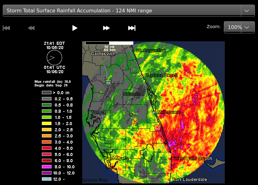
Zeta intensified and rushed in for a landfall as a 112mph Catagory 2 hurricane with a forward speed of 24mph near Cocodrie, in Terrebonne Parish, LA. It appears to have been the highest hurricane winds that have traversed New Orleans on record. Took out over 2 million electric customers as it crossed through many southeast states. It breached the burrito levee in Grand Isle. Some rescue parties were sent out after. At least six people have died. Four were hit by trees, one was electrocuted and the the other drown.
Western North Carolina and Virginia took wind and flooding damage from quick passing Zeta. The Richmond Times has an article full of pictures. There is a lot of downed trees on cars and homes as well as flooding. Below is a picture from that article of a crushed bus in Newton, NC.

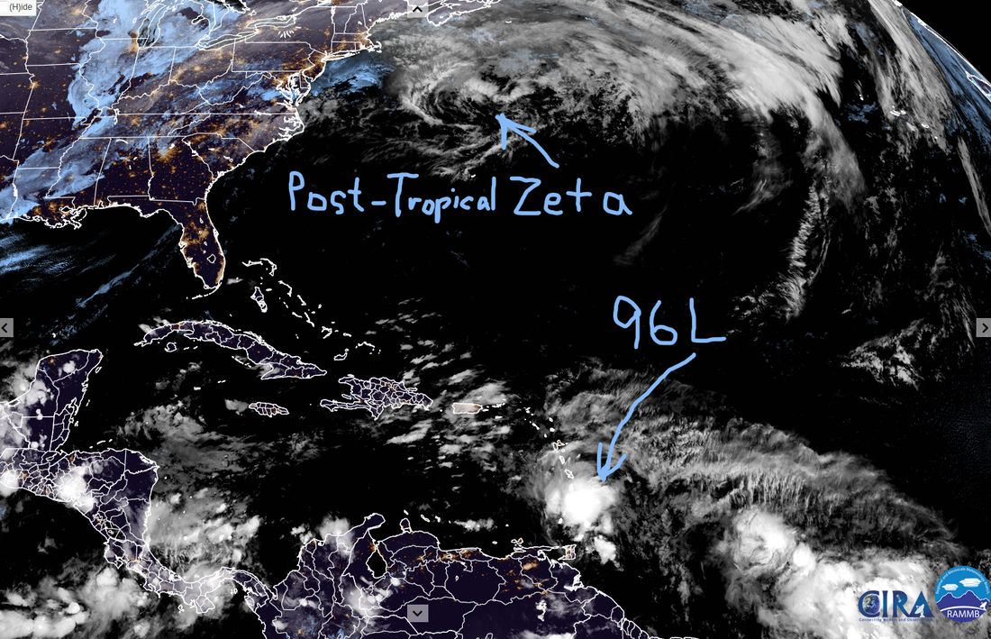
Tropics Aren't Done Yet
  NHC Key Messages  Grand Isle Surge Forecast  Zeta Slideshow
GHeroCAM1 New Orleans, LA
millertmCAM4 Belle Chasse, LA
K4QALCAM6 Slidell, LA
95L Current Images
  Tropics Photo Gallery of Recent Events
Bermuda was overall spared from the wrath of Epsilon who was at one point a category 3 hurricane.
Delta is moving into the frame above from the Eastern Caribbean as Gamma weakens on the Yucatan Peninsula. This evening, Hurricane Hunters found Delta had become the 9th Hurricane of the 2020 Atlantic storm season. Models are leaning toward Delta becoming a Major Hurricane as it passes over some of the warmest water currently on Earth. It is expected to affect Yucatan and Cuba as it tries to the clear the gap, headed to the northern Gulf Coast. Hurricane Warnings have been issued. Below is the most recent Key Messages for Delta, from the National Hurricane Center.
 Tropical Slide Show
Above is a growing slide show of saved images and gifs from Gamma and Delta.
WU Disqus was struggling with the amount of traffic. It is back with images thru the original disqus link. The other way in when it failed was the backdoor. Some are commenting at YCC as well. Most recent update on Grothar has been days ago. He is receiving hospice care now. For those in Delta's path, it is a storm weary one. Best of luck, stay safe and well..
This blog is mostly self updating. Refresh or visit again for latest..
  More info from National Hurricane Center Wunderground Mobile, AL Nexrad Snapshots of Sally
Wundercams From New Orleans to Pensacola
Refresh or visit again for latest. Click links to see videos.
Paulette and Rene are still both Tropical Storms. Paulette has the better chance to becoming a hurricane and may hit Bermuda on Sunday. It is down to 991mb and has winds of 65kts. Rene has winds of 45kts. 95L is the latest wave off of Africa. There is also two other areas of interest one east and the other west of Florida. The one already in the Gulf of Mexico is expected to move West Southwest. The one east of Florida is expected to move in a general West Northwest direction, this is now 96L. NHC has upped the odds of the one east of Florida to develop to 40% before it moves across the state. Heavy rain is expected in the Bahamas, South Florida and the Florida Keys.
With so many X's around the Southeast and storms in the Atlantic it was time for some self updating graphics.  
Some still pics to document the most active days of Hurricane Season 2020..
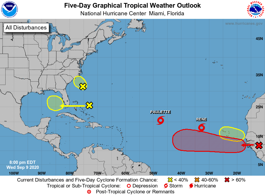 Approaching the height of Hurricane Season 2020 the tropics are active. Though the upper levels aren't too conducive for monster storms and mad divergence aloft there is the edge of a Kelvin Wave passing thru the Main Development Region. Paulette and Rene are both Tropical Storms. Paulette and the red X over Africa have the best chance at becoming hurricanes, Rene could also become a hurricane. As to where these go the models are undecided from run to run and have rarely agreed with each other. With multiple storms so close and other maybe storms trying to form, a higher level of uncertainty of forecast is in play. The red X on Africa probably has the best chance of making it across the Atlantic to landfall. Less likely, Paulette or Rene could curve out and circle back around too. Paulette currently has Bermuda in it's cone. The invest off South Carolina 94L, continues to look less likely to develop. It's recon for the afternoon was cancelled. 94L is running out of time, and is expected to be over Eastern North Carolina by Thursday afternoon. The area that has been over the Bahamas has upped it's odds to develop in the next five days to 20%. It is expected to cross Florida on Friday. 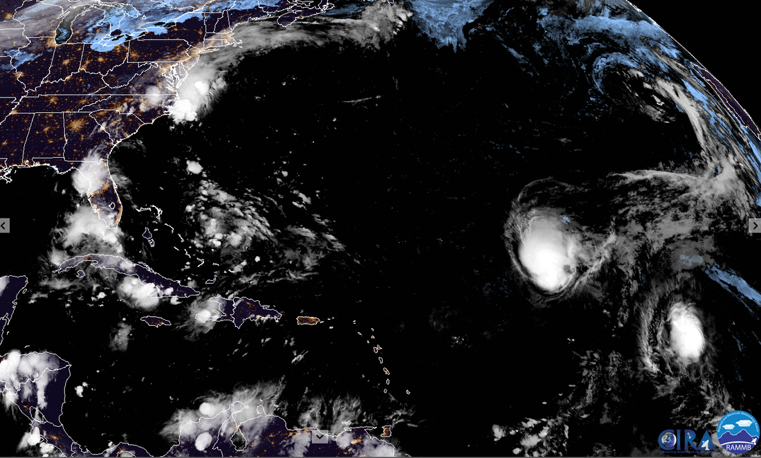 Disaster Days of 2020 Rages On China Flood Surpasses 1998 |
Current Tropics and Weather News..
Archives
January 2022
|


 RSS Feed
