|
Welcome to Skyepony's Weather Blog.
|


Elsa came from a tropical wave in the Main Development Region. It's approaching the Windward Islands where Tropical Storm Warnings are in place.
Looking at storm model verification for all the models, UKMET and that suite is the only ones really with a clue about forecast location so far. Here are Elsa forecast error in Nautical Miles every 12hrs starting at 0hr. EGR2 UKMET global model (Interpolated 12 hours) 0 26.6 23.7 - EGRI UKMET global model (Interpolated 6 hours) 0 66.7 23.7 46.7 UKX UKMET [GFS tracker] 20.1 62.9 78.8 80.7 UKX2 UKMET [GFS tracker] (Interpolated 12 hours) 0 28.2 26.6 - UKXI UKMET [GFS tracker] (Interpolated 6 hours) 0 54.7 42.7 59.6 Best of the Rest goes to: TVCX Consensus Track Guidance (2018 version, consensus of at least two of: AVNI, EGRI, HWFI, EMXI [double weight], CTCI) 0 43.7 74.3 89.2 NHC track is pretty much following this guidance with the current cone centered on that path over Cuba and the Keys. Lytton, BC Evacuated
After three days of record highs including one of 49.6C (121F) Lytton, BC caught a fire and it's 1000 or so residents fled for their lives.
Comments
Tropical Storm Danny came from a broad low that slowly tightened as it drifted west the last few days. It was declared a depression this morning and then a Tropical Storm at a Special update at 3pm. Recon just found winds of 40mph and higher gusts. A gust report of 41mph has been reported on Folly Beach. It looks to be moving toward Beaufort and Hilton Head area of South Carolina. Storm surge of 1-3ft is expected from Port Royal Sound to South Santee River.
Begin Self Updating Graphics
  End Self Updating Graphics 96L's Transformation into Danny
Osprey live cam in Savannah. They ate what looked like a fish about 8hrs ago. The mostly grown baby hung around a while, complained at the camera some. Once the rain started flew off, probably for better cover. Hear them off in the distance. They are close.
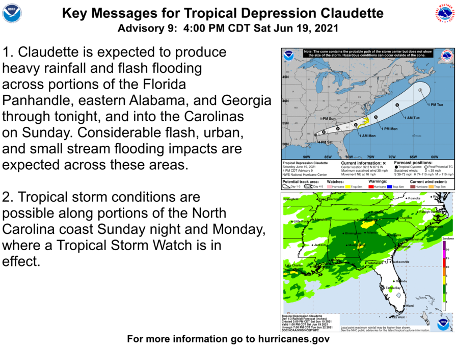
Claudette has been a dread all along to some. Predicted for weeks on the GFS model. That foreshadowed an ever changing story of the Central American Gyre pulling together to then move north, bringing anything from flooding to a well developed storm from Texas to Georgia. It brought that dread to some of season is here. Already some neighbors have partially boarded their homes in Central Florida, feeling safer just in case it happened to veer off the forecast path.
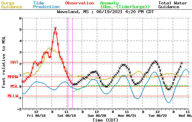
6-19-2021 Pascagoula, Ms Tropical Storm Claudette Storm surge, flooding, power flashes
6-19-2021 Mobile, Al Tropical Storm Claudette- Storm Surge shuts down Causeway- Drone
Claudette has spawned some tornadoes..
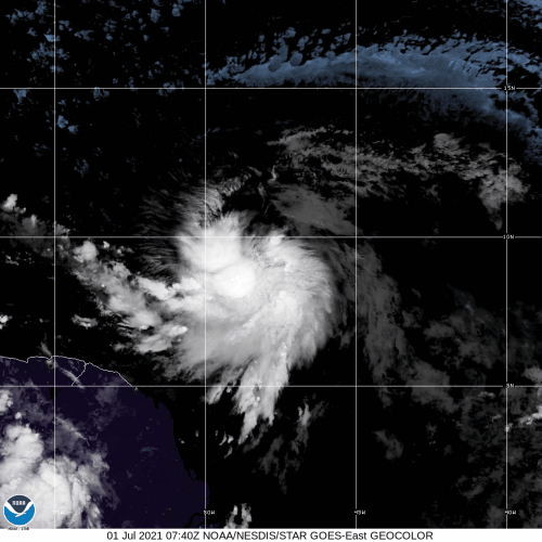
Claudette is forecast to remain at about Tropical Depression strength til it emerges on the Carolina coast and possibly strengthens to a Tropical Storm again.
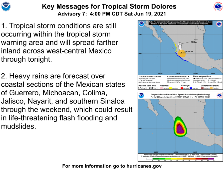
94E is now Dolores
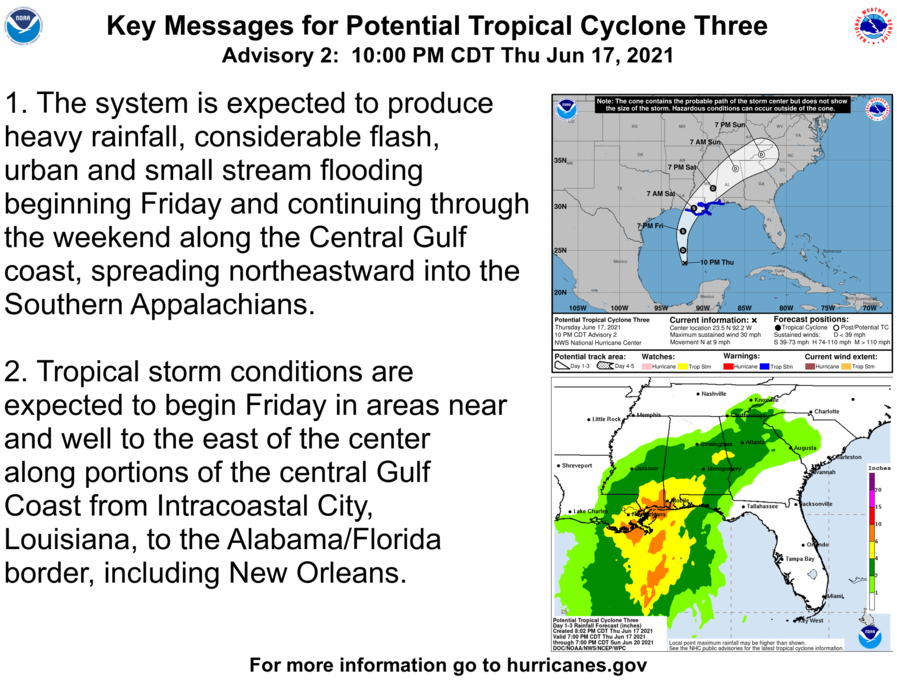
What will most likely become Claudette is expected to make a lopsided landfall and have a wet trip across the Southeast. It may very well be spent with the surface low opening up before making it's way to the warm waters of the Atlantic. GEOS shows another bit of disturbance coming across the country getting swept up in it as it goes to sea and spins back up into a Sub-tropical and then Tropical Storm. A sort of Bill repeat, quick lived and out to sea. If this plays out then the storm maybe renamed Danny.
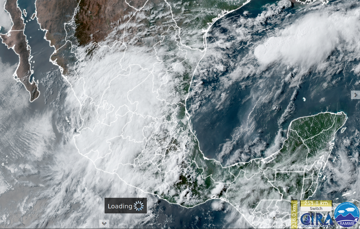
Santa, El Salvador Flooding in the Central American Gyre Caught between Potential Tropical Depression 3 and 94E. New Crop of Tropical Invests As many times happens after a long stretch of no tropical activity, several invests have been declared. Two are in the East Pacific. 92E is the farther west of the two. 93E is nearly centered on Central America. In the West Pacific there is 92W and 93W. Both are fairly unorganized with 92W currently looking the healthier of the two. 94B is a large gathering of moisture over the Bay of Bengal. 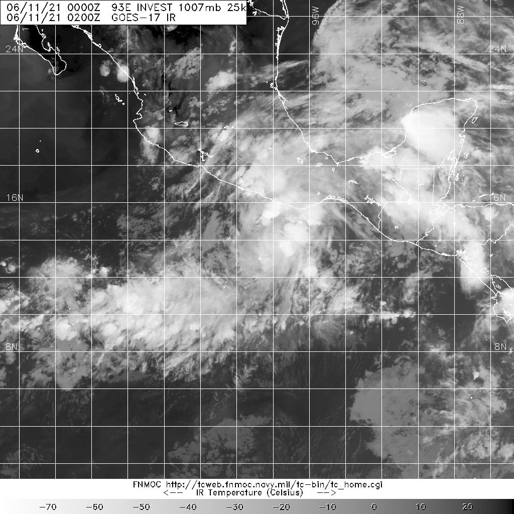 Above 93E is showing the best spin of the invests while 92W has the best convection. Huge Wave Inundated Houses and Coastal Areas After Storm in Valparaiso, Chile Vulnerability
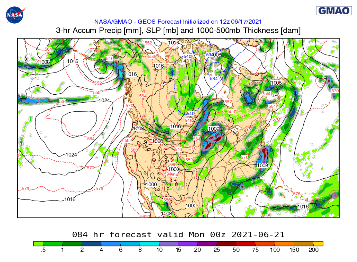
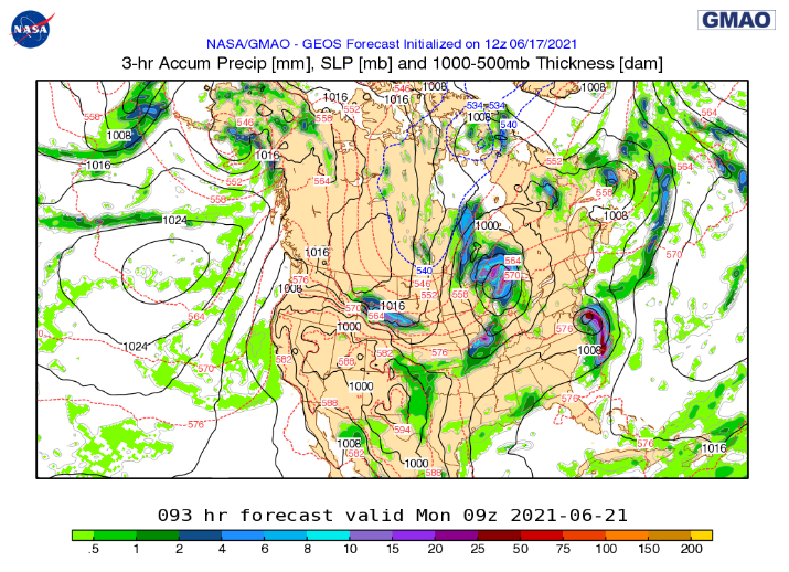
Natural disaster 9 June 2021. Huge waves flood houses and coastal areas after storm in Valparaíso, Chile NASA's 00z GEOS model had the rain off Texas coming together as it came on shore today. Has this pulsing daily with the gulf moisture, at times severe as it moves north and then over the Great Lakes. Comes off that looking more like a Tropical Depression. Exits thru Canada and Maine. Here it is coming in Corpus Christi earlier today. "Massive Tornado Hit Corpus Christi, Texas [ 03.06.2021 ] Corpus Christi Tornado Warning". NWS has several flooding reports in this area. Flooding is ongoing with several Flood Warnings, some Flash Flooding is occurring as well as a Severe Thunderstorm Warning. A large area of Texas is under a Flood Watch. More in depth info is at the NWS Corpus Christi office. There it is forecast after the Great Lakes.. 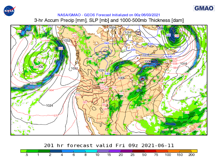
NATURAL DISASTERS this week from 19 - 22 May 2021Other notable disasters last week were flooding in both Texas and Louisiana and the eruption of Nyiragongo.
Wunderground /now/ YCC News
The old WU blog that had been existing in Discus has completed it's transition to YCC. If anyone is having trouble finding everyone click here for the direct YCC link. There is also the disqus link here, for both links select the most current entry.
The 2020 hurricane season final count is out with Zeta declared a Cat 3, changing the count to 30-14-7. That affirms Afrim Alimenti as the WU hurricane season prediction winner for the year. Congratulations! Entries for the 2021 Hurricane Predictions are due here by May 31st. Keeping Up with the Supply Disasters
Tropics
In the Western Pacific Tropical Depression #3 has formed. It is forecast to get to Tropical Storm force strength in the next 24hrs and then weaken as it interacts with land. So far it has shown good form.
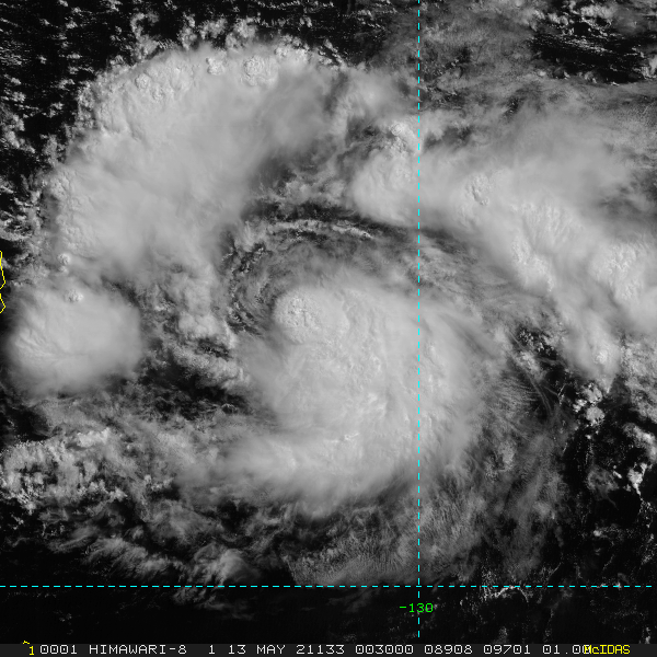
Image 1. Tropical Depression #3 located Southeast of the Philippines.
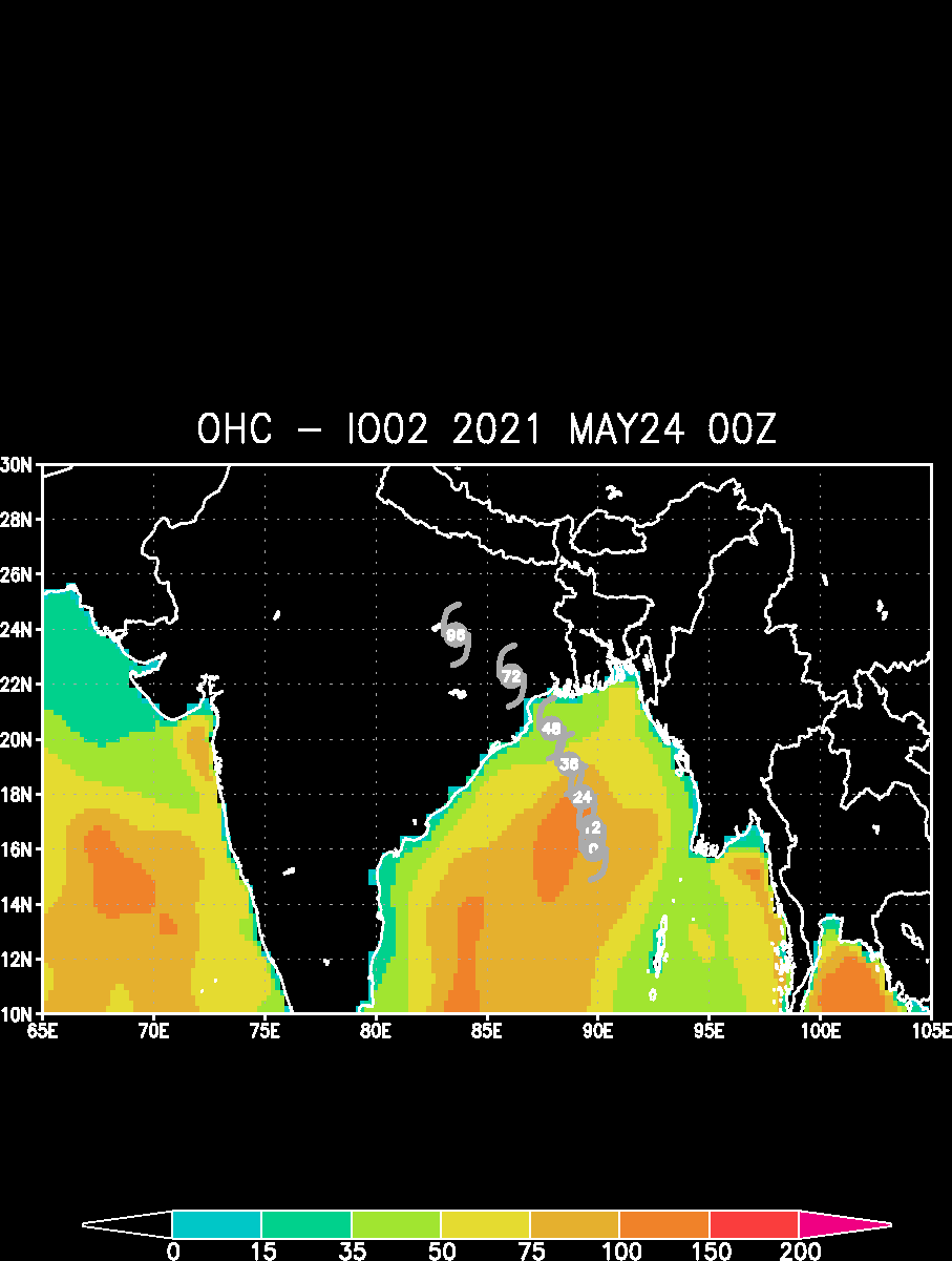
92A is expected to become at least a Category 3 storm in the Arabian Sea. Some models keep this further from India, some don't. 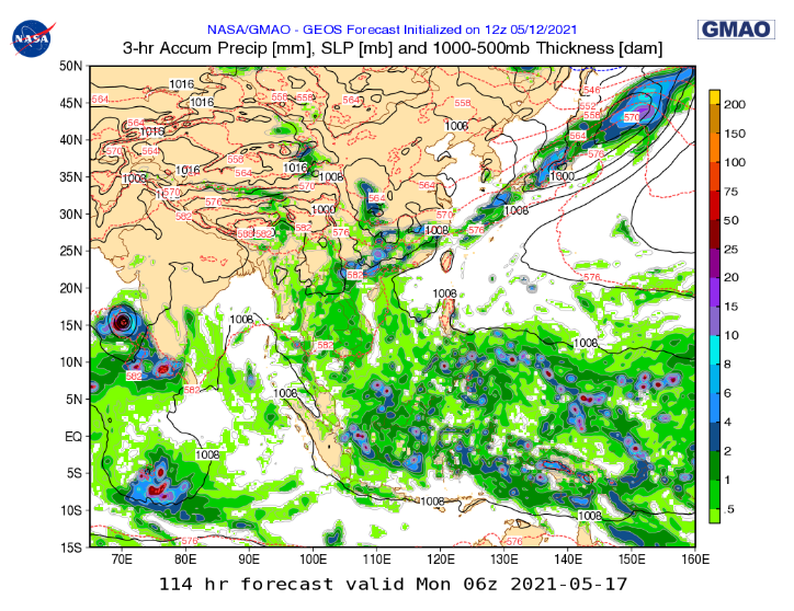
Image 2. NASA's GEOS model showing what is currently 92A blown up into a major storm after it brushed the west coast of India.
The NAVY is continuing to track the first Eastern Pacific storm of the season Andres. NOAA stopped following it a few days ago. It currently has that flock of gulls look. Tidal Bore in Indonesia
TSUNAMI-LIKE WAVES' Hit Village in Indonesia (Tidal Bore) | Kampar River (Sumatra)
697,569 views •May 7, 2021 Licet Studios Spectacular moment caught on camera when several meter high waves are speeding up to 130 km inland through the Kampar River in Indonesia. The phenomenon, called "Bono", is feared by the locals to sink ships, as at full tide during the rainy season the waves can reach a height of 20 feet (6 meters) and a speed of up to 40 km/h. The wave also attracts surfers who attempt to surf the tsunami-like wave, but as the river is also inhabited by crocodiles the surfers need to be escorted by rescue boats!
This all inspired a new Climate Connections Critter.. Supercell 
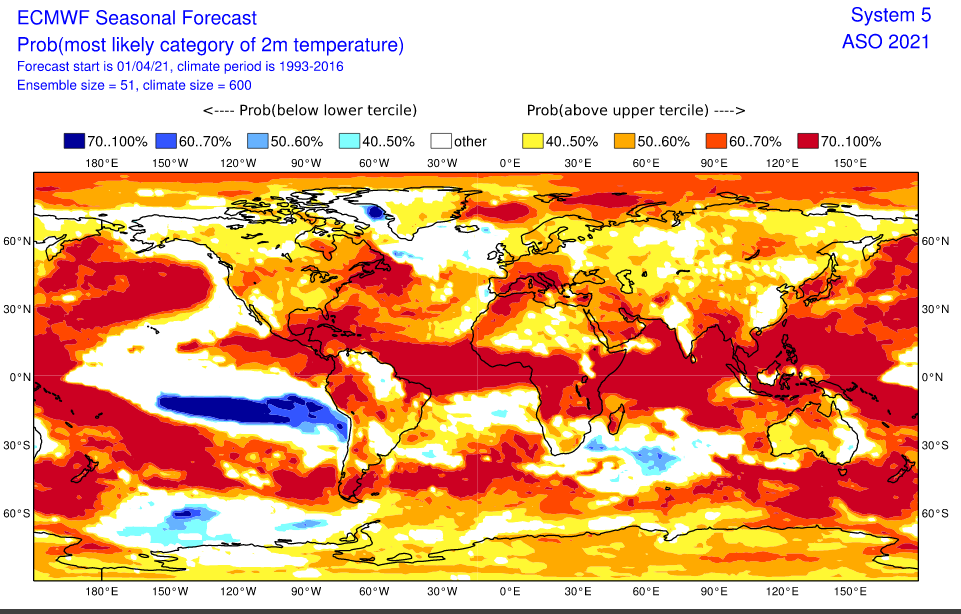
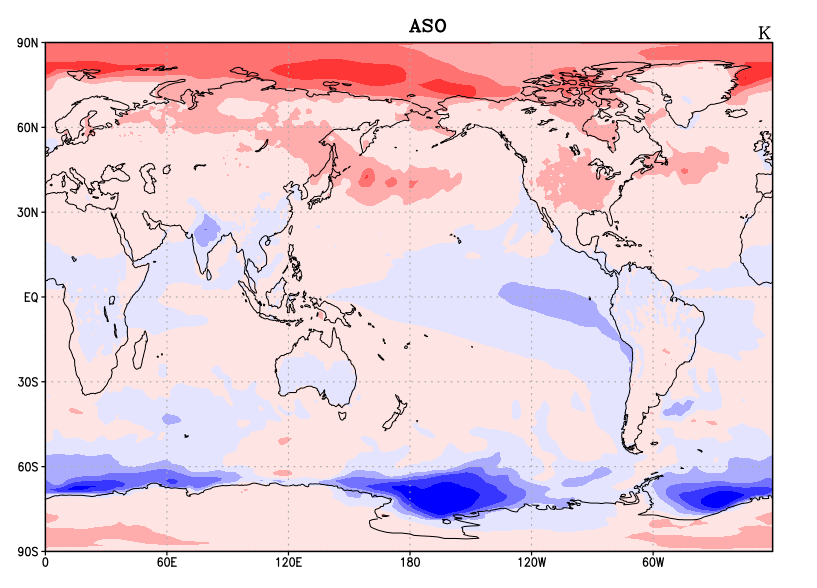
Looking ahead from April in the height of the Spring ENSO barrier models are still taking drastically different outlooks for the coming summer. Looking at my two favorite models for this, ECMWF and NASA GMAO, there is a fair spread on what ENSO might do. ECMWF is not so clear on the graph below. The plume can be viewed here. It is largely undecided with the majority being a warm neutral region 3.4. 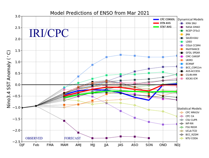 There is a lot of similarities in the summer forecast though. The cold water coming up from the Southern Hemisphere and sweeping out west across the Pacific Ocean is present in both. ECMWF just has it moving west farther south, not in the area ENSO is gauged. Both models show a hot year. ECMWF has overall hotter with less cool water in the Antarctic region. Below is a comparison of Global Temperatures at 2meters for Aug Sept Oct, ECMWF on the left and NASA's GMAO on the right. In both hot is red, cool is blue.
Overall the two least realistic looking things for these models are.. GMAO really cools much of the Arctic down to near normal some months over the summer. In past runs this cool down should have started two months ago and keeps being warmer in the near term than forecast. Expecting the Arctic heat anomaly to not be as hot this summer as it has been through the Northern Hemisphere colder seasons as this is how Climate Change has been rolling, but probably not as cool as GMAO is forecasting. The extreme La Nina forecast is a bit of an outlier too. Though still wouldn't be surprised to see La Nina re-strengthen some as we go into summer. As for ECMWF the cold plume forming so far south in the Pacific Ocean looks unrealistic. The Antarctic maybe forecast a little warm as well.
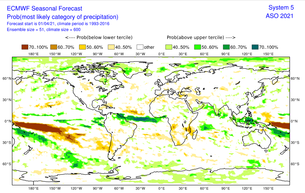
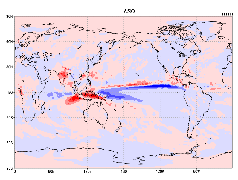
Above is a comparison of global precipitation anomalies for Aug Sept and Oct. Left is ECMWF, right is NASA's GMAO (blue is less rain than normal, red is more). Both generally show more rain expected around the poles with large areas of extreme dry in the Pacific and a rainier than normal Atlantic Ocean. Overall the coming months look hot and dry for much of the land portions of the planet. If the trend of late holds, when it rains chances are it may downpour very heavy precipitation and possibly frozen, in the form of hail. |
Current Tropics and Weather News..
Archives
January 2022
|


 RSS Feed
